
Source: fertilizer price information
Domestic weather conditions
1. Fact: Heavy rain, local rainstorm or heavy rainstorm occurred in parts of Guangdong, Guangxi, Hainan Island and other places yesterday
From 8:00 yesterday to 6:00 today, heavy rain and local torrential rain occurred in parts of southern Guangxi, southwest Guangdong, eastern Hainan Island, northwest Yunnan and southeast Tibet, and local torrential rain (100~192mm) occurred in Qionghai, Wanning, Lingshui and other places in Hainan;
The maximum hourly rainfall in some of the above areas is 30~80mm.
In addition, the rainfall (snow) or sleet in some parts of eastern Qinghai is 1-5mm, and 8.9mm in Guoluo; Part of northwest Xinjiang, middle east Inner Mongolia, western Heilongjiang and other regions have gusts of 7~9 levels, and local gusts of 10~11 levels.
2. Key weather forecast: there will be heavy precipitation in Jiangnan, South China and other places
On May 2, moderate to heavy rain, local rainstorm or heavy rainstorm occurred in southeastern Guangxi, southwestern Guangdong, northern Hainan Island, etc.
From May 3 to 5, there will be a new round of strong precipitation process from west to east in southern China. Some areas in eastern Guizhou, Hunan, Jiangxi, Guangxi, Guangdong, western Fujian and other places will have heavy rain, local heavy rain; The above areas are locally accompanied by severe convective weather such as thunderstorm, gale or hail.
In addition, from May 2 to 3, there was light to moderate rain (snow or sleet) in the central and eastern parts of the Qinghai Tibet Plateau, and moderate to heavy snow and local blizzard in high-altitude mountains in eastern Tibet, eastern and southern Qinghai, and central and northern Sichuan Plateau.
Specific forecast for the next three days in China
From 08:00 on May 2 to 08:00 on May 3, there were light to moderate snow or sleet in northern and eastern Tibet, eastern and southern Qinghai, central and northern parts of the western Sichuan Plateau, and local heavy to heavy snow;
Some areas in southeast Tibet, north central Hunan, western and southeast Yunnan, central and western Guangdong, central and northern Hainan Island and other places have moderate to heavy rain, of which southeast Qinghai, southwest Guangdong, northeast Hainan Island and other places have heavy rain or heavy rain (100~120mm).
Some areas in northeastern Heilongjiang, eastern Zhejiang and other places have winds of 4~6 degrees, and some areas in northern Tibet have winds of 6~7 degrees (see Figure 1).
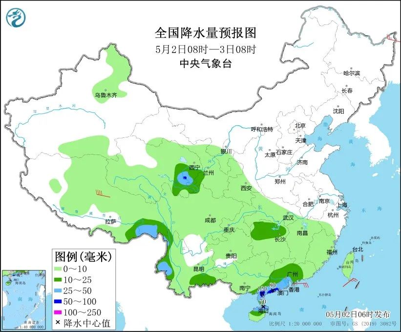 Figure 1 National Precipitation Forecast Map (08:00, May 2 to 08:00, May 3)
 From 08:00 on May 3 to 08:00 on May 4, there was light to moderate snow or sleet in eastern Tibet, eastern Qinghai, central and northern parts of western Sichuan Plateau, and local heavy snow;
Some areas in eastern Jianghan, central and western Jiangnan, southeast of southwest China, and most of South China have moderate to heavy rain, of which some areas in central and northern Hunan and southwest China, northern Jiangxi, southeast of Guizhou, eastern Guangxi, central and western Guangdong, and coastal areas in southwest China have heavy rain, local heavy rain (100~150 mm) (see Figure 2).
Some areas in the middle east of Inner Mongolia, eastern Zhejiang and other places have 4~6 wind.
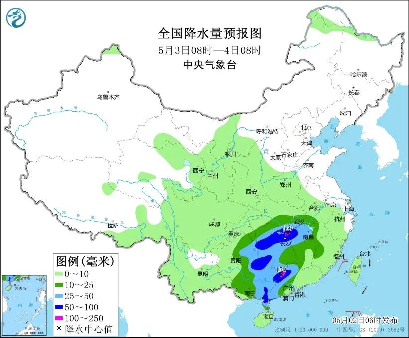 Figure 2 National Precipitation Forecast Map (08:00, May 3 to 08:00, May 4)
 From 08:00 on May 4 to 08:00 on May 5, there were moderate to heavy rains in some areas of western Jianghuai, most of Jiangnan, and most of South China, among which there were heavy rains or torrential rains (100~180 mm) in some areas of southern Hunan, most of Jiangxi, northwestern Fujian, northeastern Guangxi, and northwestern Guangdong.
Some areas in the northeast of Inner Mongolia have 4-5 winds (see Figure 3).
Some areas in the middle east of Inner Mongolia, eastern Zhejiang and other places have 4~6 wind; There are southerly winds of magnitude 5~7 and gust of magnitude 8 in the northern waters of the East China Sea and Beibu Gulf.
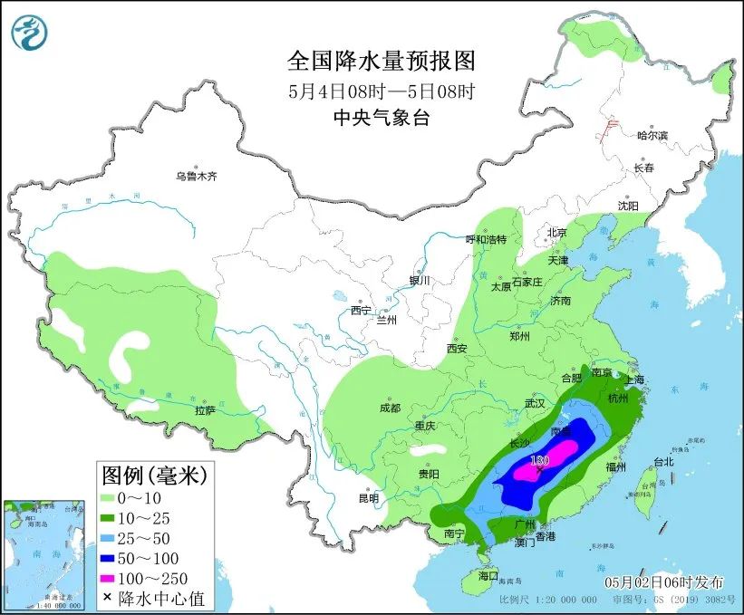 Figure 3 National Precipitation Forecast Map (08:00, May 4 to 08:00, May 5)
Safe, fast and guaranteed futures account opening on Sina cooperation platform

Massive information, accurate interpretation, all in Sina Finance APP
Editor in charge: Dai Ming SF006