-
nuscenes_tutorial.ipynb -
nuscenes_lidarseg_panoptic_tutorial.ipynb -
nuimages_tutorial.ipynb -
can_bus_tutorial.ipynb -
map_expansion_tutorial.ipynb -
prediction_tutorial.ipynb
background
preparation
tree -L 2 . ├── basemap │ ├── boston-seaport.png │ ├── singapore-hollandvillage.png │ ├── singapore-onenorth.png │ └── singapore-queenstown.png ├── expansion │ ├── boston-seaport.json │ ├── singapore-hollandvillage.json │ ├── singapore-onenorth.json │ └── singapore-queenstown.json └── prediction └── prediction_scenes.json initialization
pip install nuscenes-devkit import matplotlib.pyplot as plt import tqdm import numpy as np from nuscenes.map_expansion.map_api import NuScenesMap from nuscenes.map_expansion import arcline_path_utils from nuscenes.map_expansion.bitmap import BitMap nusc_map = NuScenesMap(dataroot='/Users/lau/data_sets/nuscenes', map_name='singapore-onenorth') Rendering
Multi layer rendering
fig, ax = nusc_map.render_layers(nusc_map.non_geometric_layers, figsize=1) 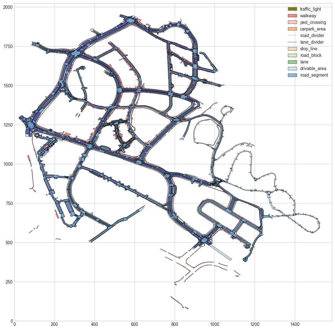
Rendering basic map of lidar
bitmap = BitMap(nusc_map.dataroot, nusc_map.map_name, 'basemap') fig, ax = nusc_map.render_layers(['lane'], figsize=1, bitmap=bitmap) 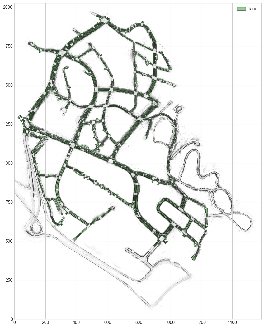
Render a specific record of a map layer
fig, ax = nusc_map.render_record('stop_line', nusc_map.stop_line[14]['token'], other_layers=[], bitmap=bitmap) 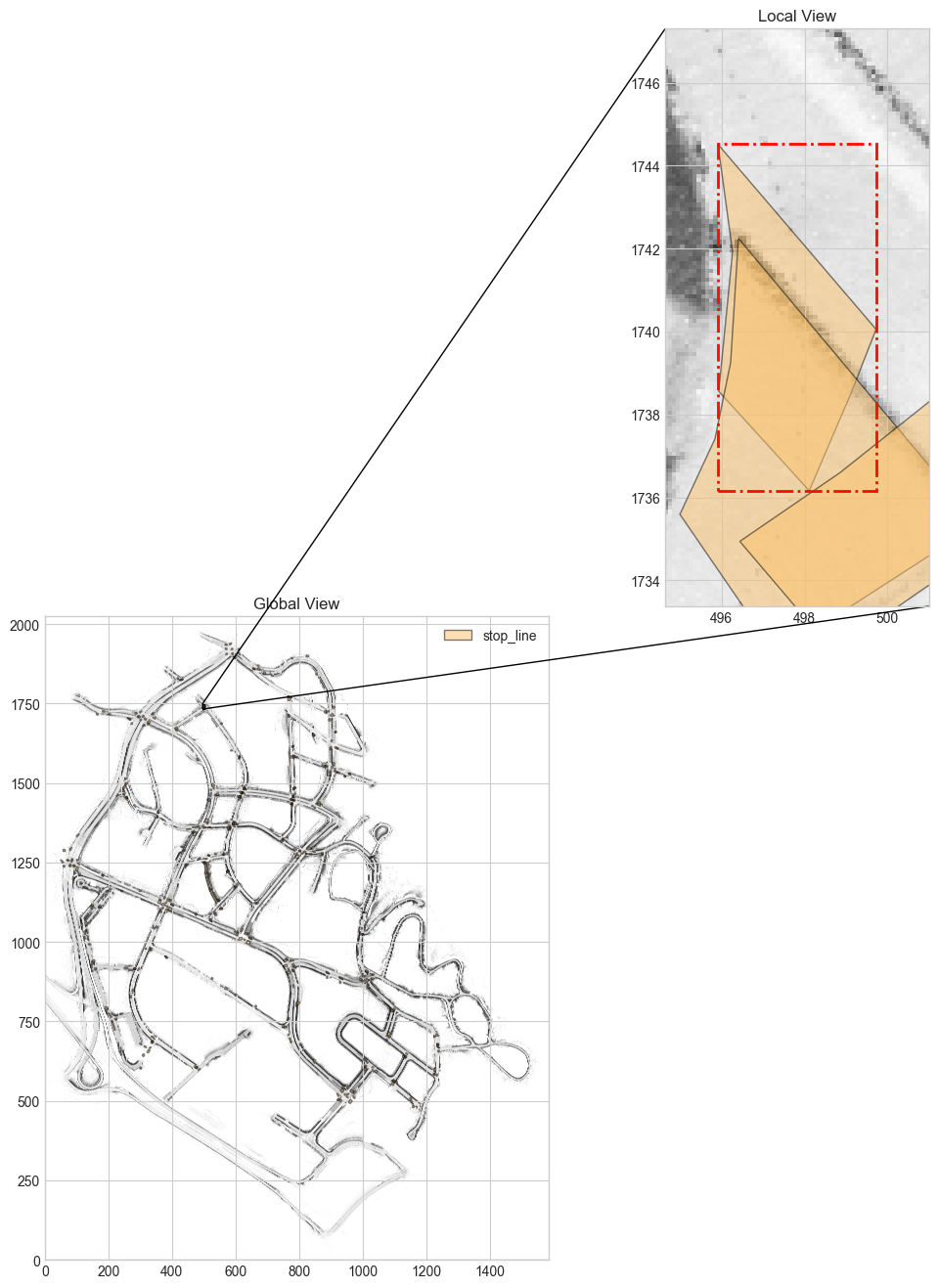
Render Binary Map Mask Layer
patch_box = (300, 1700, 100, 100) patch_angle = 0 # Default orientation where North is up layer_names = ['drivable_area', 'walkway'] canvas_size = (1000, 1000) map_mask = nusc_map.get_map_mask(patch_box, patch_angle, layer_names, canvas_size) map_mask[0] #Output results array([[0, 0, 0, ..., 0, 0, 0], [0, 0, 0, ..., 0, 0, 0], [0, 0, 0, ..., 0, 0, 0], ..., [0, 0, 0, ..., 1, 1, 1], [0, 0, 0, ..., 1, 1, 1], [0, 0, 0, ..., 1, 1, 1]], dtype=uint8)
figsize = (12, 4) fig, ax = nusc_map.render_map_mask(patch_box, patch_angle, layer_names, canvas_size, figsize=figsize, n_row=1) 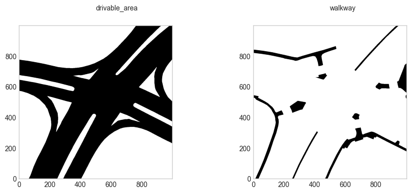
fig, ax = nusc_map.render_map_mask(patch_box, 45, layer_names, canvas_size, figsize=figsize, n_row=1) 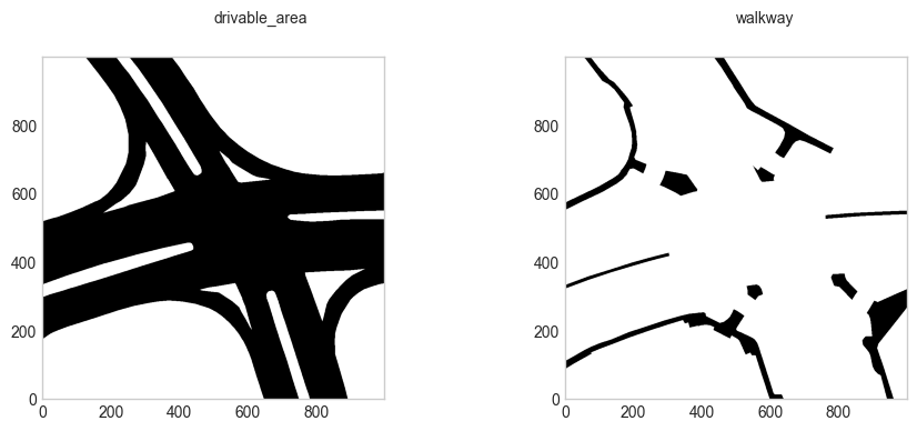
Render map layers on images
# Init nuScenes. Requires the dataset to be stored on disk. from nuscenes.nuscenes import NuScenes nusc = NuScenes(dataroot='/Users/lau/data_sets/nuscenes', version='v1.0-mini', verbose=False) # Pick a sample and render the front camera image. sample_token = nusc.sample[9]['token'] layer_names = ['road_segment', 'lane', 'ped_crossing', 'walkway', 'stop_line', 'carpark_area'] camera_channel = 'CAM_FRONT' nusc_map.render_map_in_image(nusc, sample_token, layer_names=layer_names, camera_channel=camera_channel) 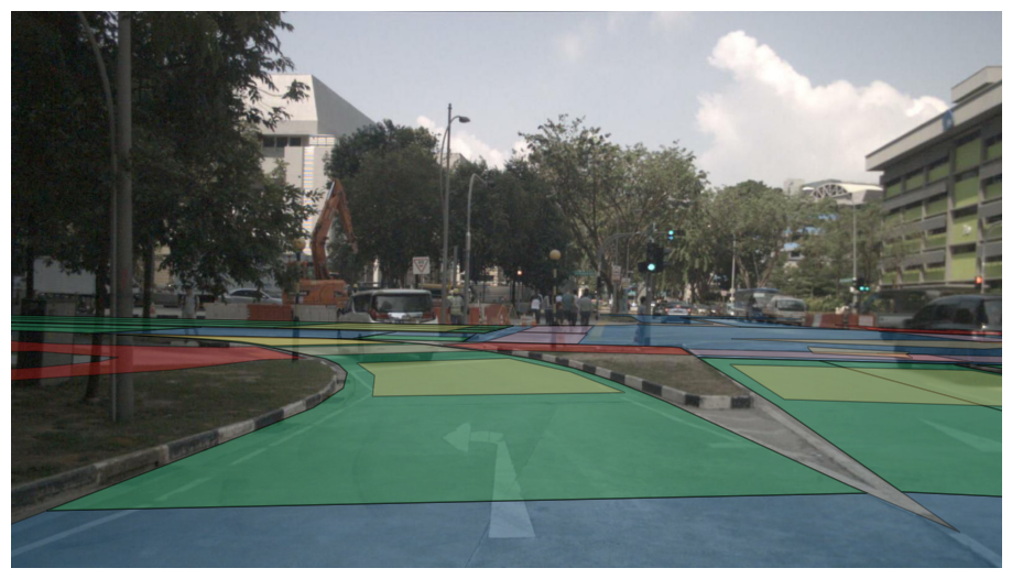
Select vehicle attitude on the map
# Init NuScenes. Requires the dataset to be stored on disk. from nuscenes.nuscenes import NuScenes nusc = NuScenes(dataroot='/Users/lau/data_sets/nuscenes', version='v1.0-mini', verbose=False) # Render ego poses. nusc_map_bos = NuScenesMap(dataroot='/Users/lau/data_sets/nuscenes', map_name='boston-seaport') ego_poses = nusc_map_bos.render_egoposes_on_fancy_map(nusc, scene_tokens=[nusc.scene[1]['token']], verbose=False) 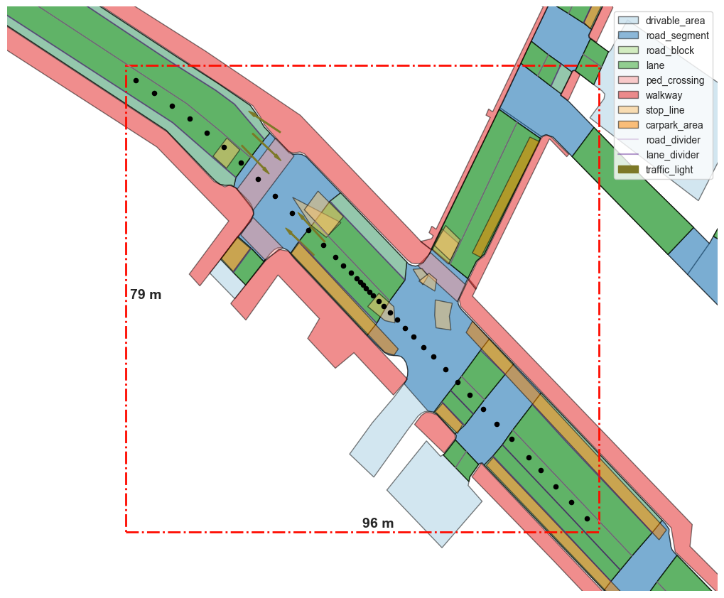
Navigation
x = 873 y = 1286 print('Road objects on selected point:', nusc_map.layers_on_point(x, y), '\n') print('Next road objects:', nusc_map.get_next_roads(x, y)) #Output results Road objects on selected point: {'drivable_area': 'c3e28556-b711-4581-9970-b66166fb907d', 'road_segment': '57416e99-8919-4a28-985b-033a16938243', 'road_block': '', 'lane': '', 'ped_crossing': '', 'walkway': '', 'stop_line': '', 'carpark_area': ''} Next road objects: {'road_segment': ['3493d68c-5217-4d21-ae1b-3cbf4467dd77', '4b0e50c0-c549-49a2-9077-57a8cba8ab55', '5428b143-6343-4045-ac81-466df3dcc510'], 'road_block': ['5c286ee8-7b4d-4cd8-84bb-7486e77ba827', '8b33213a-692e-4c5f-a69a-efa6836f5316', '9aa7a714-30ba-4892-a276-c033928a8ae2', '9c506cc4-7d14-475d-8063-22a5b9bc257f', 'b7cc94f4-3882-4df2-a9ae-9349925809a1', 'e0c4f027-ea81-40f2-bafc-3fb8e8ab78c3'], 'lane': ['525b6716-a12e-4dd0-8541-91ef672ce39b', '5fdd162d-477d-4bc4-ada3-535d79a9f4b1', '8658217b-87d6-4f8b-96be-35d53100247d', 'b7378bda-dedf-4f97-9d87-b0dd602fdab5', 'bce7caf7-5e33-48d6-b0aa-8b5b641c8ce5', 'f747ce8a-2396-4da3-a8e6-45201ed470d6']}
nusc_map.render_next_roads(x, y, figsize=1, bitmap=bitmap) 
Processing lane
nusc_map.render_centerlines(resolution_meters=0.5, figsize=1, bitmap=bitmap) 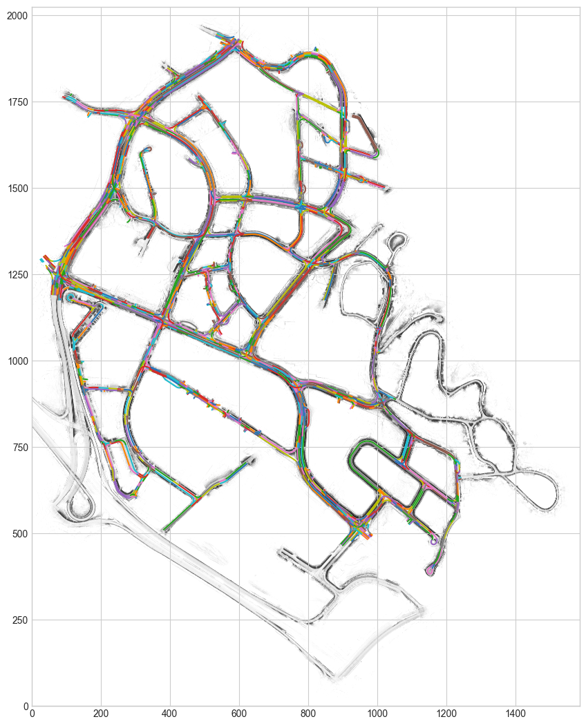
x, y, yaw = 395, 1095, 0 closest_lane = nusc_map.get_closest_lane(x, y, radius=2) closest_lane #Output results '5933500a-f0f2-4d69-9bbc-83b875e4a73e' lane_record = nusc_map.get_arcline_path(closest_lane) lane_record #Output results [{'start_pose': [421.2419602954602, 1087.9127960414617, 2.739593514975998], 'end_pose': [391.7142849867393, 1100.464077182952, 2.7365754617298705], 'shape': 'LSR', 'radius': 999.999, 'segment_length': [0.23651121617864976, 28.593481378991886, 3.254561444252876]}] nusc_map.get_incoming_lane_ids(closest_lane) #Output results ['f24a067b-d650-47d0-8664-039d648d7c0d'] nusc_map.get_outgoing_lane_ids(closest_lane) ['0282d0e3-b6bf-4bcd-be24-35c9ce4c6591', '28d15254-0ef9-48c3-9e06-dc5a25b31127']
poses = arcline_path_utils.discretize_lane(lane_record, resolution_meters=1) poses #Output results [(421.2419602954602, 1087.9127960414617, 2.739593514975998), (420.34712994585345, 1088.2930152148274, 2.739830026428688), (419.45228865726136, 1088.6732086473173, 2.739830026428688), (418.5574473686693, 1089.0534020798073, 2.739830026428688), (417.66260608007724, 1089.433595512297, 2.739830026428688), (416.76776479148515, 1089.813788944787, 2.739830026428688), (415.87292350289306, 1090.1939823772768, 2.739830026428688), (414.97808221430097, 1090.5741758097668, 2.739830026428688), (414.0832409257089, 1090.9543692422567, 2.739830026428688), (413.1883996371168, 1091.3345626747464, 2.739830026428688), (412.29355834852475, 1091.7147561072363, 2.739830026428688), (411.39871705993266, 1092.0949495397263, 2.739830026428688), (410.5038757713406, 1092.4751429722162, 2.739830026428688), (409.6090344827485, 1092.8553364047061, 2.739830026428688), (408.7141931941564, 1093.2355298371958, 2.739830026428688), (407.81935190556436, 1093.6157232696858, 2.739830026428688), (406.92451061697227, 1093.9959167021757, 2.739830026428688), (406.0296693283802, 1094.3761101346656, 2.739830026428688), (405.1348280397881, 1094.7563035671556, 2.739830026428688), (404.239986751196, 1095.1364969996453, 2.739830026428688), (403.3451454626039, 1095.5166904321352, 2.739830026428688), (402.4503041740119, 1095.8968838646251, 2.739830026428688), (401.5554628854198, 1096.277077297115, 2.739830026428688), (400.6606215968277, 1096.657270729605, 2.739830026428688), (399.7657803082356, 1097.0374641620947, 2.739830026428688), (398.8709390196435, 1097.4176575945846, 2.739830026428688), (397.9760977310515, 1097.7978510270746, 2.739830026428688), (397.0812564424594, 1098.1780444595645, 2.739830026428688), (396.1864151538673, 1098.5582378920544, 2.739830026428688), (395.2915738652752, 1098.9384313245444, 2.739830026428688), (394.3967548911081, 1099.318677260896, 2.739492242286598), (393.5022271882191, 1099.69960782173, 2.738519982101022), (392.60807027168346, 1100.0814079160527, 2.737547721915446), (391.71428498673856, 1100.4640771829522, 2.7365754617298705)]
closest_pose_on_lane, distance_along_lane = arcline_path_utils.project_pose_to_lane((x, y, yaw), lane_record) print(x, y, yaw) closest_pose_on_lane #Output results 395 1095 0 (396.25524909914367, 1098.5289922434013, 2.739830026428688) # Meters distance_along_lane #Output results twenty-seven point five
arcline_path_utils.length_of_lane(lane_record) #Output results thirty-two point zero eight four five five four zero three nine four two three four one
#0 means this is a straight lane. arcline_path_utils.get_curvature_at_distance_along_lane(distance_along_lane, lane_record) #Output results zero Explore data
my_patch = (300, 1000, 500, 1200) fig, ax = nusc_map.render_map_patch(my_patch, nusc_map.non_geometric_layers, figsize=(10, 10), bitmap=bitmap) 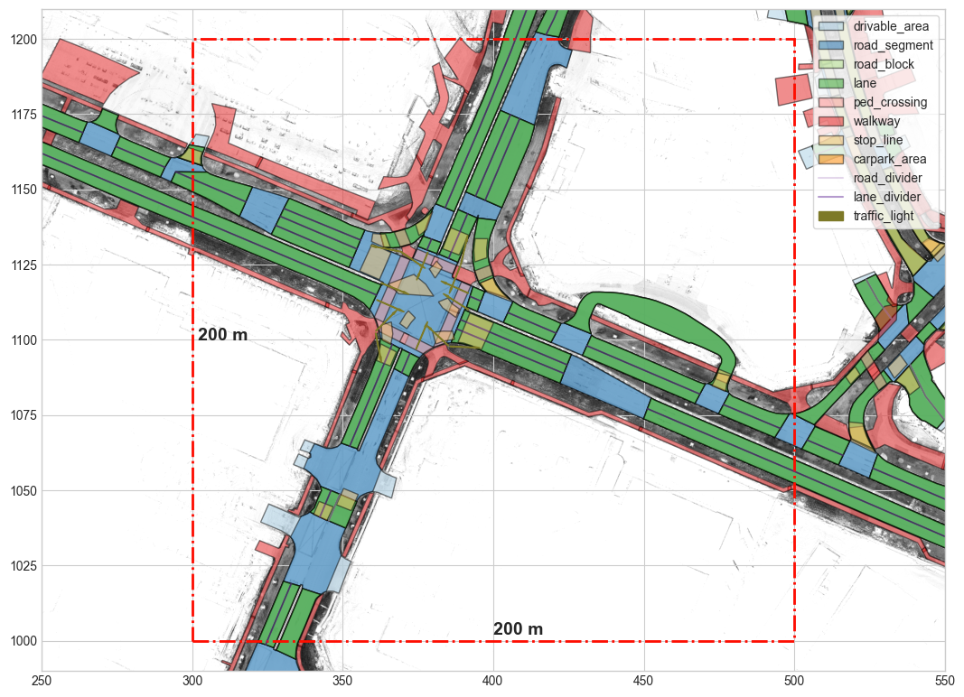
-
The option within will return all non geometric records in the map block. -
The option intersect will return all non geometric records intersected with the map block.
records_within_patch = nusc_map.get_records_in_patch(my_patch, nusc_map.non_geometric_layers, mode='within') records_intersect_patch = nusc_map.get_records_in_patch(my_patch, nusc_map.non_geometric_layers, mode='intersect')
layer = 'road_segment' print('Found %d records of %s (within).' % (len(records_within_patch[layer]), layer)) print('Found %d records of %s (intersect).' % (len(records_intersect_patch[layer]), layer)) #Output results Found 25 records of road_segment (within). Found 36 records of road_segment (intersect).
my_point = (390, 1100) layers = nusc_map.layers_on_point(my_point[0], my_point[1]) assert len(layers['stop_line']) > 0, 'Error: No stop line found!'
nusc_map.record_on_point(my_point[0], my_point[1], 'stop_line') #Output results '942dc2b1-345c-4fe7-83d0-9eeed8202709'
nusc_map.get_bounds('stop_line', 'ac0a935f-99af-4dd4-95e3-71c92a5e58b1') #Output results (751.928131680929, 920.9848298895206, 762.8608345788314, 929.439260149884) layer
nusc_map.layer_names #Output results ['polygon', 'line', 'node', 'drivable_area', 'road_segment', 'road_block', 'lane', 'ped_crossing', 'walkway', 'stop_line', 'carpark_area', 'lane_connector', 'road_divider', 'lane_divider', 'traffic_light']
geometric_layers Define geometric entities in the map: -
Nodes (2D points) are the basis of all geometric layers. -
A line consists of two or more nodes. Formally, a Line record can be composed of multiple line segments. -
A polygon consists of three or more nodes. Polygons can have holes, which distort their formal definition. Holes are defined as a sequence of nodes that form polygon holes.
-
non_geometric_layers Represents a physical entity in a map. They can have multiple geometric representations (e.g., roadable areas), but must be strictly of one type (e.g road_segment , lane_divider )。
map layer
nusc_map.geometric_layers #Output results ['polygon', 'line', 'node']
sample_node = nusc_map.node[0] sample_node #Output results {'token': '2163fdc8-77fc-4c1c-a099-70bc5be9f9b7', 'x': 994.6139837360693, 'y': 1054.5199816348131}
sample_line = nusc_map.line[2] sample_line #Output results {'token': '19f89773-f466-4d21-a583-4a963e6fe042', 'node_tokens': ['ee2752d0-5fc9-495c-aa4b-fc24f703db1b', '48b2f4ea-9781-4cf2-82ff-624267be98d6', '9995a31d-089b-45f1-81ec-11925d17dbda']}
sample_polygon = nusc_map.polygon[3] sample_polygon.keys() #Output results dict_keys(['token', 'exterior_node_tokens', 'holes']) sample_polygon['exterior_node_tokens'][:10] #Output results ['de837055-7009-42f2-80c7-cb224a9ce750', '86ee21c3-4a35-4f0e-9286-57b4cde9a2df', 'ac4be197-c315-4233-98e0-d52007091090', '3ae2328f-cf1d-4597-8cc6-c9ac9f28f3b5', '3bb30867-05e0-4687-bd67-613ad5ad6476', '507d041c-5a0a-439e-9fbe-e57556e02d93', '19b5ae73-163a-47a7-b6f6-deea88d8d72f', 'c0eedac8-f7d0-44d1-becc-535183fbf496', '9fe84337-f37d-4873-bd7b-be3922203a36', 'cb8ee715-d481-49d6-a6c7-c765afccdfd5'] sample_holes = sample_polygon['holes'][0] sample_holes #Output results {'node_tokens': ['13e0ec9d-e592-4d15-a30f-e61c5a04546f', 'ed06f702-2a3f-4c7e-b200-6c41d20f04c7', '8e7b8e2f-7218-4e00-bce3-1f79245f5946', '542f7094-634e-4972-9108-602184f81ec8', '45dd272a-cda0-4de5-89b3-28ff539881e7', 'c8952a38-8199-4580-b27c-ce7631f598cd', 'f3def455-f19a-4379-9903-71628c0f9303', '16083beb-d393-4045-b903-bbd9a126d0bc', '80879705-d6ec-4f52-b54a-859a13c2670c', '1980fcec-6ba3-4fb4-b3c1-0126886cc29f', '1c01e9ae-2974-4863-856d-56f6a472355a', '85feaeae-1802-44f2-90af-9e04ca5934ff', 'af88a07c-4aa6-479d-bc1e-7b9a824fc750', 'f9a9097e-e844-486f-a497-f3521dd6bf2c', '86f21780-6f2a-4cbe-8aac-f13a0b5adf3f', '35e8c5f7-b89d-494b-9840-725cd4fa6010', 'da77624e-765e-44f8-8374-c7513684f015', '28aa464f-93db-4ef1-a907-9abf07b5a380', '0e3ba3fd-3e85-4c26-bf20-d9144e5864cc', 'ab924ff2-c6fe-41c0-b8f4-dc9db5fc1a48']} Non map layers
nusc_map.non_geometric_layers #Output results ['drivable_area', 'road_segment', 'road_block', 'lane', 'ped_crossing', 'walkway', 'stop_line', 'carpark_area', 'road_divider', 'lane_divider', 'traffic_light']
sample_drivable_area = nusc_map.drivable_area[0] sample_drivable_area #Output results {'token': 'c3e28556-b711-4581-9970-b66166fb907d', 'polygon_tokens': ['fff7b0c9-1eaf-4988-afe3-e4e4607f85e3', 'd235013d-2a07-4181-9862-c666b49a79b4', '0bbf311c-405d-433b-a097-7d9c292a9b87', 'b4dfb634-2721-42d9-aa5d-0f8ec9a2fa31', 'c4b4c925-6ddb-4e4b-a4ca-609e1ca626c2', 'a60970c7-86cd-4169-ae9a-b9b51e4ec950', '1209379e-bc10-4d65-9fb1-0ee938032130']} fig, ax = nusc_map.render_record('drivable_area', sample_drivable_area['token'], other_layers=[]) 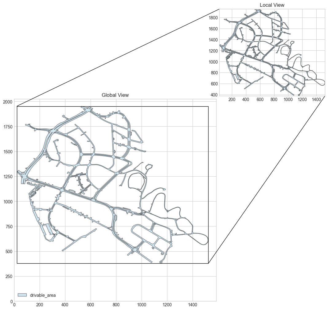
sample_road_segment = nusc_map.road_segment[600] sample_road_segment #Output results {'token': 'c366bb7b-1f3b-4840-b7d3-9d3362b02589', 'polygon_token': '254a099d-d884-4c5f-a444-d3703163f173', 'is_intersection': True, 'drivable_area_token': 'c3e28556-b711-4581-9970-b66166fb907d', 'exterior_node_tokens': ['15d4c84c-a459-492d-8fae-619c6eccb60c', '4e336b1e-b67c-4452-bad5-fedfb970fac4', '6060b6c9-26c8-4887-8b7d-0aa67404cd1a', '54305c13-60f8-4976-a555-8d915eb9ae4f', '6a2e3ae8-72c8-4605-a644-8c74b8454c98', 'f9190d61-9d7a-46cb-9f6d-909f51f7565a', 'eef9c998-204a-40f6-ad27-a600849e1b68', 'bfa79595-ab08-46b5-ae1a-c66c57ebbe9f', '439fc8a3-c175-4511-99bf-e993a016c280', 'bd2ca111-5da9-4e2d-b4c1-13cedb1f96ef', 'a95821b5-a97e-401c-b96c-938037a8fbb0', '10d9a934-338a-413b-8835-f8ae1d9abb87', '61372da3-bed1-4524-bca4-26cb2f4d0f8e', '4f639960-ad63-40e2-a58f-2e7387a5c846'], 'holes': []}
sample_intersection_road_segment = nusc_map.road_segment[3] sample_intersection_road_segment #Output results {'token': '00cbbc19-252e-4eef-a9e9-3158446bd794', 'polygon_token': 'c6df6bdd-698c-40b2-b2a0-728eb5172efa', 'is_intersection': True, 'drivable_area_token': 'c3e28556-b711-4581-9970-b66166fb907d', 'exterior_node_tokens': ['a29ee8f6-53a5-44c3-878f-5137e06b343d', '4d518646-6a49-4bad-96c8-e37af381a189', '6958b257-2443-4366-afb2-cfb9585e756b', 'debfdfe0-d701-4833-ada6-ec8dd1d612b4', 'c92b7476-10ac-4222-b5c0-f0512aca89b9', 'd261ca11-b827-4cc2-ab34-092970b7d6fa', '3df5c6fc-92e5-40f2-bacf-6322f4896495', '8007e1bd-3ed6-4fab-8530-5717cfb93fc9', 'cc8cf624-d4e1-4fed-a35a-d27ff7b3e4e9', '067e77f2-7443-46b1-a7e4-3ce0af7501a5', 'a918f42d-5f99-477a-ad8f-027e1af656d8', '6063aace-dbc6-4761-a40d-e593d34ae8e6'], 'holes': []}
fig, ax = nusc_map.render_record('road_segment', sample_intersection_road_segment['token'], other_layers=[]) 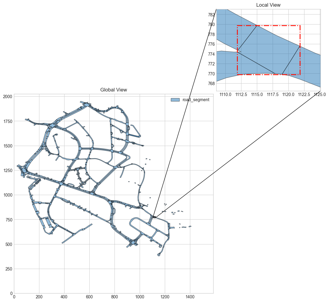
sample_road_block = nusc_map.road_block[0] sample_road_block #Output results {'token': '002d8233-c9bf-4a9b-9d53-be86cd6cf73f', 'polygon_token': '29fc4c78-75ae-4777-adab-f33d93591661', 'from_edge_line_token': 'b0d2163e-732b-4be6-b6f7-2add8b4c7e8f', 'to_edge_line_token': '7ce97362-1133-4c19-a73c-5cfa8f0d64f0', 'road_segment_token': '85a06614-958c-461f-bc11-6cadd68efa7d', 'exterior_node_tokens': ['46cf43f6-30ea-437e-83b3-42af3ce2783b', 'aca16135-79a1-4acd-a68f-3918c38d54be', 'ce31539b-d8c8-45a0-94df-3ac3a585225b', '26704699-79a6-4d4c-8ca2-d65ffb3ac11b', '2d0168af-7952-416d-8aff-7512130fb73d', 'e3fa777d-d87a-45f9-bd41-5364e3bb9dd2', 'bedec7db-1f55-4639-9826-ab8639ee250b', '05243627-6e25-472d-af1f-aca0ff30b00c'], 'holes': []}
fig, ax = nusc_map.render_record('road_block', sample_road_block['token'], other_layers=[]) 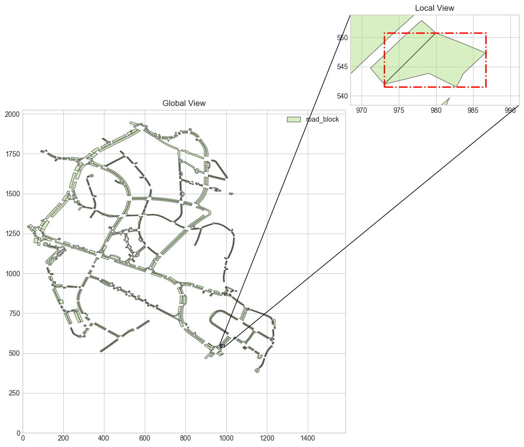
sample_lane_record = nusc_map.lane[600] sample_lane_record #Output results {'token': 'a6f12a5c-f6fa-4e99-993f-4cbd6f982c65', 'polygon_token': 'd50a64b4-021c-4f73-8496-f6491eb0d3fa', 'lane_type': 'CAR', 'from_edge_line_token': '32f811fd-a2d8-4dc8-9785-8c43d0ea947c', 'to_edge_line_token': 'ca27a4ad-37ca-44b7-8703-85aa39119a47', 'left_lane_divider_segments': [], 'right_lane_divider_segments': [], 'exterior_node_tokens': ['124f5c61-f391-43f0-a245-32a325243a73', '55ad1d37-fe95-4e5c-a43e-1148ad4a13f6', 'e3df7273-cb2e-4fef-8849-72141d549a1c', '9b5764b9-ca40-4622-afec-494d979b716a', '1066e47d-486e-45cf-affe-59c4e4e93fa9', '741bede3-d6c2-44c0-966f-fdce30f57817', 'f5f4e292-056a-499b-b097-2e70e07435a7', 'bbdf380c-9aed-4082-88e5-834eb39bca9e', 'a040018c-3f38-4779-8876-6741b4aa4f81', '0d110059-c96f-413d-afd9-65963d4823fd', '1d0feda2-ee54-4ebd-aaa1-7c669089b4ef', '445a42dc-dbac-4fea-b03d-ece94729d0e8', 'd8f8d28e-8be1-4c8a-a008-6c852b86363b'], 'holes': [], 'left_lane_divider_segment_nodes': [], 'right_lane_divider_segment_nodes': []}
lane_type : indicates whether cars or bicycles are allowed to drive in the lane. from_edge_line_token and to_edge_line_token : indicates the traffic direction of the lane. left_lane_divider_segments and right_lane_divider_segment : indicates the separator of the lane. left_lane_divider_segment_nodes and right_lane_divider_segment_nodes : Indicates the node that forms the lane separator.
fig, ax = nusc_map.render_record('lane', sample_lane_record['token'], other_layers=[]) 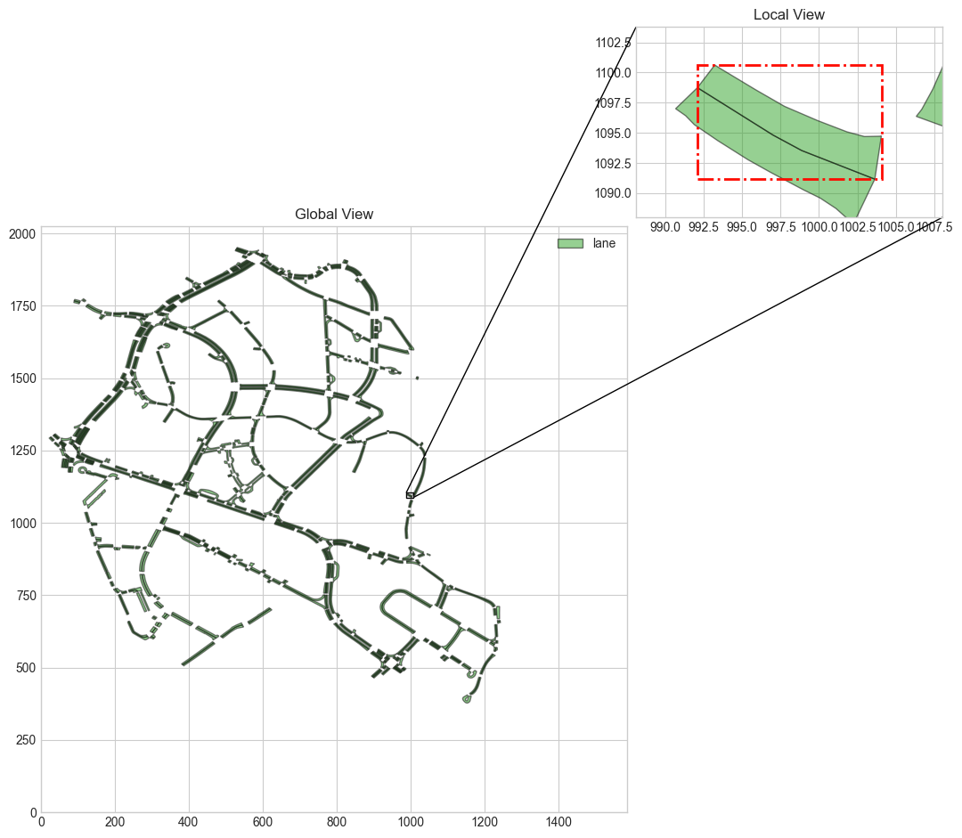
sample_ped_crossing_record = nusc_map.ped_crossing[0] sample_ped_crossing_record #Output results {'token': '027c4ccd-56c9-4980-9949-1d42bb36f23c', 'polygon_token': '62138b18-6dd1-4c1e-8f11-7a2c8d5783c8', 'road_segment_token': 'af7744d2-6dfe-4b9f-ab9a-58cc155f3f08', 'exterior_node_tokens': ['58cf4a19-d28e-44b1-b4c0-bc217e50da1e', '0e3fda05-0936-4cbb-acbd-fc582750b3d3', '6a0f7286-8e6d-4fb5-b874-c830f090a05a', '0f45b051-0f14-469d-bde3-e8975b4d67cb'], 'holes': []} fig, ax = nusc_map.render_record('ped_crossing', sample_ped_crossing_record['token']) 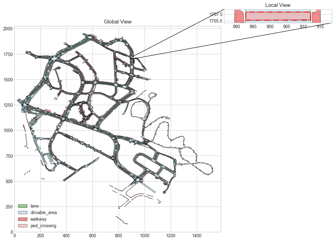
sample_walkway_record = nusc_map.walkway[0] sample_walkway_record #Output results {'token': '00a01743-8d10-41ca-849e-ef6a32bee77d', 'polygon_token': '17ff2a4b-a5c2-41d2-abf5-4a8aa07cb30f', 'exterior_node_tokens': ['e7aa76d5-8368-4749-900d-dd2cbb4971e6', 'c7187b86-fdb8-4eec-ba71-0f2c6ee0b57b', '8bd36561-55ef-4ff6-ab55-583dc59f2b73', '47db713d-fc9f-49bd-b5ba-6d89123f6357', '442e2766-733f-4147-b1cf-4238de3b93e1', '5a831f39-0352-4fcf-ab76-e696c9d5e651', 'ac7839a1-73ef-4f39-80f0-e32ee2d816ae', '4434e104-1317-4bcd-bddf-ac0abb4e158c', '1cc537c7-1b78-443a-8513-8894cb807c8a', '85cff4b3-a56b-45e5-8e6b-880a73860696', '9344380b-375f-480f-9877-aa75e21b7acd', '6c5a6416-ab0c-4221-842a-bc5aa97da61b', '60e66d85-c5c1-4d27-8d67-d5ce28c2dac1', '68c442df-c38f-482e-b863-10afae9c69ce', '519240d4-5c8c-45e6-8d85-5ec78eac43bf', 'f12f278c-e0ca-4c18-ab14-d6b259885687', '95e6e737-310d-4a9a-99aa-02dc4365ff19', 'f69e2a9d-f43b-4a3d-834b-bc0de489caf5'], 'holes': []} fig, ax = nusc_map.render_record('walkway', sample_walkway_record['token']) 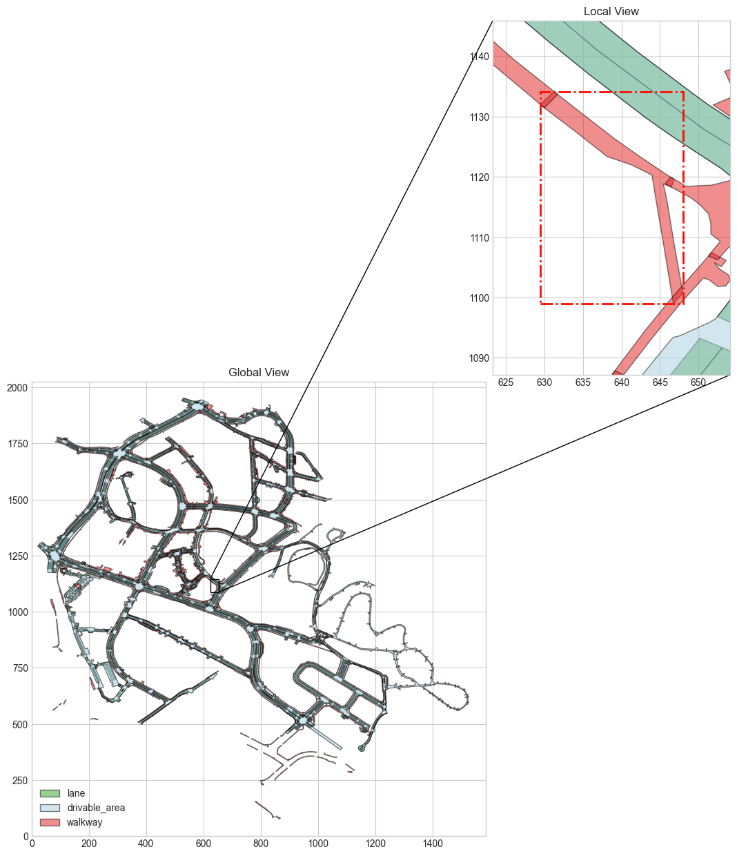
sample_stop_line_record = nusc_map.stop_line[1] sample_stop_line_record #Output results {'token': '00904b8f-3166-47b8-9cbb-30062caec0eb', 'polygon_token': '90102f73-9921-4d2a-8e07-148503868957', 'stop_line_type': 'TURN_STOP', 'ped_crossing_tokens': ['96748923-eabf-4142-8458-92ff580e997f'], 'traffic_light_tokens': [], 'road_block_token': '', 'exterior_node_tokens': ['a3e110de-2443-406f-bf54-ef9b4dc46939', 'e5d038c8-f964-4ae2-b498-9952496c801f', 'bbec1377-0e20-4888-9f79-2a1aa50b3b88', '37a078fa-2804-412e-b8b9-682fe21ad8be', '50597561-e04f-4ea1-894a-cfd2c212aef0', 'b05b2d23-3a12-493d-9d8d-e57f4f8ddc60'], 'holes': [], 'cue': [{'token': '96748923-eabf-4142-8458-92ff580e997f', 'polygon_token': 'f8a39c38-1d04-4dc0-9e35-f63966e56250', 'road_segment_token': '6ea9d0a6-65e7-4038-ae50-4fb89a4c296d', 'exterior_node_tokens': ['7931be00-b6a7-437d-9335-e4314dbe47b4', '1f6f7c4a-27a2-4a18-96bd-fe597546440f', 'a28f6633-a23e-44f6-8355-0c06df42005e', '235431b5-9f71-452d-a3b2-bdeaaa44aa41'], 'holes': []}]}
stop_line_type : The type of stop line, which indicates the reason for the automatic driving vehicle to stop. ped_crossing_tokens : If stop_line_type by PED_CROSSING , indicates the associated information. traffic_light_tokens : If stop_line_type by TRAFFIC_LIGHT , indicates the associated information. road_block_token : indicates and road_block The associated information of can be blank by default. cues Field contains this record as stop_line Reason for. An area may become a stop line for several reasons: -
If stop_line_type If it is "PED_CROSSING" or "TURN_STOP", the prompt is ped_crossing record. -
If stop_line_type If it is "TRAFFIC_LIGHT", the prompt is traffic_light record. -
If stop_line_type If it is "STOP_SIGN" or "YIELD", there is no prompt information.
-
fig, ax = nusc_map.render_record('stop_line', sample_stop_line_record['token']) 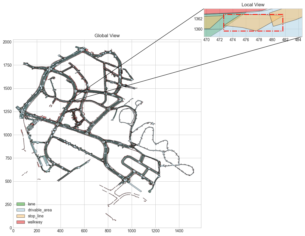
sample_carpark_area_record = nusc_map.carpark_area[1] sample_carpark_area_record #Output results {'token': '0a711883-2477-4eb5-aef8-cc9ad3e3158a', 'polygon_token': 'eca315c8-cfb7-4759-a91a-d148d08ef2eb', 'orientation': 2.5073506567369885, 'road_block_token': '2b60cc1b-0882-4ef3-8207-f7cb3561aff9', 'exterior_node_tokens': ['0043375d-b853-4149-94a5-3ca6c984e3d8', '5aa572e1-1848-4739-bbd8-f5934fb3e1ea', '5419cf3e-9e02-4683-adae-fe0dcd948644', 'ba9efc27-c461-402f-a172-e451e92ef7c8'], 'holes': []}
orientation : indicates the direction of parking, expressed in radians. road_block_token : indicates and road_block The associated information of.
fig, ax = nusc_map.render_record('carpark_area', sample_carpark_area_record['token']) 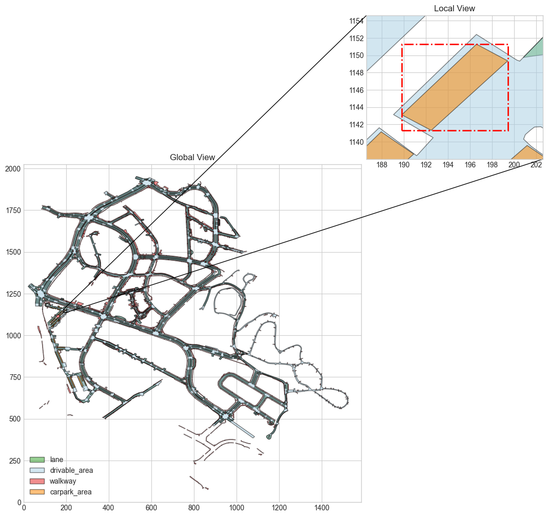
sample_road_divider_record = nusc_map.road_divider[0] sample_road_divider_record #Output results {'token': '00bbfc65-0b44-4b4c-b517-6d87dc02529c', 'line_token': '98c91318-5854-41ac-9210-001b57b8185f', 'road_segment_token': 'b1ed2f76-bfcd-4b0c-b367-7a20cf707b95', 'node_tokens': ['4e2605d4-b9f4-41f9-a03c-032c8d4a3c24', '1cbbdda6-5ee6-4b4d-8bcc-30af18094978']}
fig, ax = nusc_map.render_record('road_divider', sample_road_divider_record['token']) 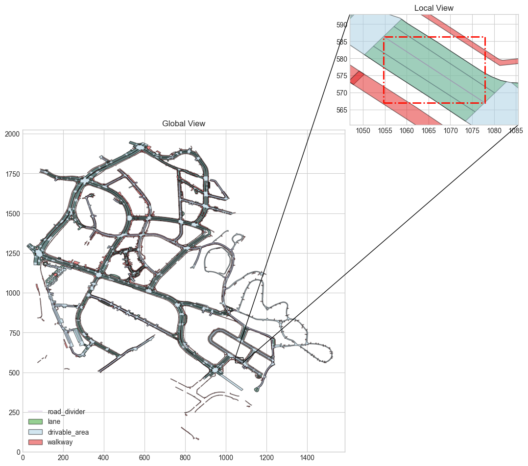
sample_lane_divider_record = nusc_map.lane_divider[0] sample_lane_divider_record #Output results {'token': '00569b72-a7dc-4cdf-9bf3-7f3583c6dbae', 'line_token': '9ac741dc-20b5-44f3-9f0a-41e371a722ee', 'lane_divider_segments': [{'node_token': '57d546eb-682c-4540-871c-2e8d6a67f2de', 'segment_type': 'DOUBLE_DASHED_WHITE'}, {'node_token': 'fef2c634-7096-4b48-bf87-6575d2a67b56', 'segment_type': 'DOUBLE_DASHED_WHITE'}, {'node_token': '153990f1-b0da-4243-a065-e4a99d29e180', 'segment_type': 'DOUBLE_DASHED_WHITE'}, {'node_token': '8ad3000f-c1e9-4eda-8bf1-c5f64a879c54', 'segment_type': 'NIL'}], 'node_tokens': ['57d546eb-682c-4540-871c-2e8d6a67f2de', 'fef2c634-7096-4b48-bf87-6575d2a67b56', '153990f1-b0da-4243-a065-e4a99d29e180', '8ad3000f-c1e9-4eda-8bf1-c5f64a879c54']}
fig, ax = nusc_map.render_record('lane_divider', sample_lane_divider_record['token']) 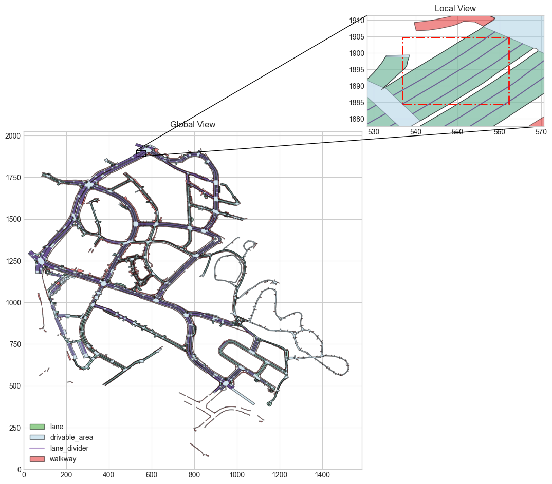
sample_traffic_light_record = nusc_map.traffic_light[0] sample_traffic_light_record #Output results {'token': '00590fed-3542-4c20-9927-f822134be5fc', 'line_token': '5bffb006-bce8-44a4-a466-5580f1d748fd', 'traffic_light_type': 'VERTICAL', 'from_road_block_token': '71c79c48-819c-4b17-ad28-2a9e82ba1596', 'items': [{'color': 'RED', 'shape': 'CIRCLE', 'rel_pos': {'tx': 0.0, 'ty': 0.0, 'tz': 0.632, 'rx': 0.0, 'ry': 0.0, 'rz': 0.0}, 'to_road_block_tokens': []}, {'color': 'YELLOW', 'shape': 'CIRCLE', 'rel_pos': {'tx': 0.0, 'ty': 0.0, 'tz': 0.381, 'rx': 0.0, 'ry': 0.0, 'rz': 0.0}, 'to_road_block_tokens': []}, {'color': 'GREEN', 'shape': 'CIRCLE', 'rel_pos': {'tx': 0.0, 'ty': 0.0, 'tz': 0.13, 'rx': 0.0, 'ry': 0.0, 'rz': 0.0}, 'to_road_block_tokens': []}, {'color': 'GREEN', 'shape': 'RIGHT', 'rel_pos': {'tx': 0.0, 'ty': -0.26, 'tz': 0.13, 'rx': 0.0, 'ry': 0.0, 'rz': 0.0}, 'to_road_block_tokens': ['bd26d490-8822-469b-ae60-74f6c0c9e1cb']}], 'pose': {'tx': 369.2207339994191, 'ty': 1129.3945093980494, 'tz': 2.4, 'rx': 0.0, 'ry': 0.0, 'rz': -0.6004778487509836}, 'node_tokens': ['8e483ef5-75e5-417a-bc78-fa7750297fb1', '78a4b686-3207-48fa-ae2a-d5f875e0ee37']}
traffic_light_type : indicates the horizontal or vertical direction of traffic lights. from_road_block_tokens : indicates the road obstacles indicated by the traffic lights. items : indicates the bulb of the traffic light. pose : indicates the attitude of traffic lights.
sample_traffic_light_record['items'] #Output results [{'color': 'RED', 'shape': 'CIRCLE', 'rel_pos': {'tx': 0.0, 'ty': 0.0, 'tz': 0.632, 'rx': 0.0, 'ry': 0.0, 'rz': 0.0}, 'to_road_block_tokens': []}, {'color': 'YELLOW', 'shape': 'CIRCLE', 'rel_pos': {'tx': 0.0, 'ty': 0.0, 'tz': 0.381, 'rx': 0.0, 'ry': 0.0, 'rz': 0.0}, 'to_road_block_tokens': []}, {'color': 'GREEN', 'shape': 'CIRCLE', 'rel_pos': {'tx': 0.0, 'ty': 0.0, 'tz': 0.13, 'rx': 0.0, 'ry': 0.0, 'rz': 0.0}, 'to_road_block_tokens': []}, {'color': 'GREEN', 'shape': 'RIGHT', 'rel_pos': {'tx': 0.0, 'ty': -0.26, 'tz': 0.13, 'rx': 0.0, 'ry': 0.0, 'rz': 0.0}, 'to_road_block_tokens': ['bd26d490-8822-469b-ae60-74f6c0c9e1cb']}]
reference resources
-
https://github.com/nutonomy/nuscenes-devkit/tree/master/python-sdk/nuscenes/map_expansion -
https://colab.research.google.com/github/nutonomy/nuscenes-devkit/blob/master/python-sdk/tutorials/map_expansion_tutorial.ipynb
