All service products
Developer Channel
Service upgrade
Sign in
Vehicle Map Solution
Provide multi-level vehicle map services for commercial vehicles/motorcycles and other vehicle enterprises, with standard vehicle navigation, AR and lane level high-precision navigation, auxiliary automatic driving map, handcart interconnection and
Comprehensive services such as safety and compliance car cloud meet the needs of car enterprises for full scene maps
contact us
Leading in car navigation and map data services make the driving experience more intelligent

Commercial vehicle on-board navigation

Provide safe and compliant on-board navigation for trucks and buses, which can intelligently avoid physical restrictions and traffic regulations, and support voice/team/AR navigation/lane level navigation/handcart interconnection and other functions.

Motorcycle on-board navigation

It flexibly supports two modes of mobile phone projection and front mounted vehicle navigation, which can intelligently circumvent the traffic regulation restrictions in multiple cities across the country, and has rich interactive functions such as team talk/footprint navigation/handcart interconnection. Watch video

ADAS Map

The high-precision over the horizon map data engine for L2 level auxiliary automatic driving supports the output of slope/curvature/heading/speed limit/traffic dynamic data and other information with standard ADAS protocol.

Vehicle map data

For the in house navigation construction mode of vehicle enterprises, it provides SD/LD/ADAS multi-level map data services with high visibility and high coverage.

Vehicle traffic dynamic data service

It provides dynamic data services such as minute level updated lane level accurate real-time road conditions, massive accidents/regulations/bad weather and other dynamic events, and traffic restriction information covering multiple cities.

Vehicle online map API

Provide rich online map API services such as high availability location retrieval, positive/negative geocoding, route planning, SVG map display, weather query, etc.

Intelligent voice

The small intelligent voice adapted to the car machine scene can realize full voice control of the map, and Meitron personalized customized voice can bring warmth experience.

Safety compliance car cloud

Provide dynamic data management cloud services such as safe and compliant vehicle tracks and private static POI data management cloud services to help vehicle enterprises achieve data closed-loop.

Mobile terminal map service

The iOS/Android map SDK with comprehensive functions and excellent performance can be provided for mobile phone owner applications to help build mobile applications with more extreme experience.

Solution Architecture
Multiple industry scenarios
Map data and API service scheme
  • Vehicle map data

    High visibility, high coverage SD Pro Map Data and accurate minute level real-time traffic dynamic data can support the construction of vehicle navigation and auxiliary automatic driving map data base

  • Intelligent route planning service

    Support the multi route intelligent route planning and the issuance of detailed route navigation information such as guidance, zoomed in map and real-time road conditions to improve the intelligent navigation experience

  • Rich online map APIs

    Provide full process online map services, including high-definition smooth SVG vector map and high-precision satellite map services, as well as intelligent POI search and forward/reverse geocoding services

On board navigation products for commercial vehicles and motorcycles
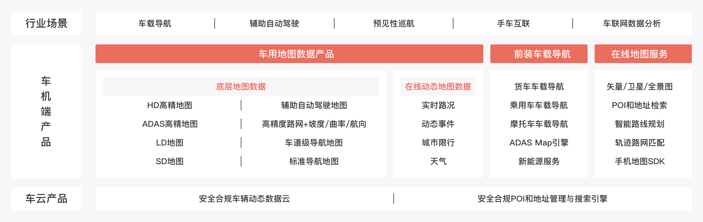
  • Standard car navigation

    Equipped with the latest Baidu Map intelligent navigation engine, it can intelligently avoid the restrictions on trucks and motorcycles, support AR navigation, intelligent voice interaction, handcart interconnection and OTA, and can adapt to vehicle and machine systems with different performance

  • High precision lane level navigation and live AR vehicle navigation

    Sub meter high-precision positioning combines with sub meter lane level road network data to achieve lane level refined navigation. Immersive real scene AR navigation integrates ADAS early warning to improve driving safety

  • Rich interactive functions such as group intercom and footprint

    Support team real-time location sharing, real-time voice intercom, footprint heating, footprint navigation, sending to the car and other interactive functions to meet the travel needs of motorists

Commercial vehicle ADAS Map products
  • High precision ADAS Map Data

    High precision gradient, curvature and heading ADAS data, combined with basic road network of commercial vehicles and real-time traffic dynamic data, meet ACC adaptive cruise fuel saving and active safety requirements

  • ADAS standard engine

    The map engine of ADAS V2 standard protocol supports multi scenario customization and development, is stable, efficient and small in size, supports security compliance OTA, and upgrades and repairs reach users in a timely manner

  • Intelligent VDR positioning and sub meter high precision positioning

    The leading VDR intelligent inertial navigation positioning technology can solve the problem of positioning loss/drift in tunnel/elevated/urban canyon areas, and upgrade the sub meter high-precision positioning scheme to achieve lane level positioning

Deep satisfaction of multiple industry demand scenarios
Win win hand in hand and jointly build industry ecology