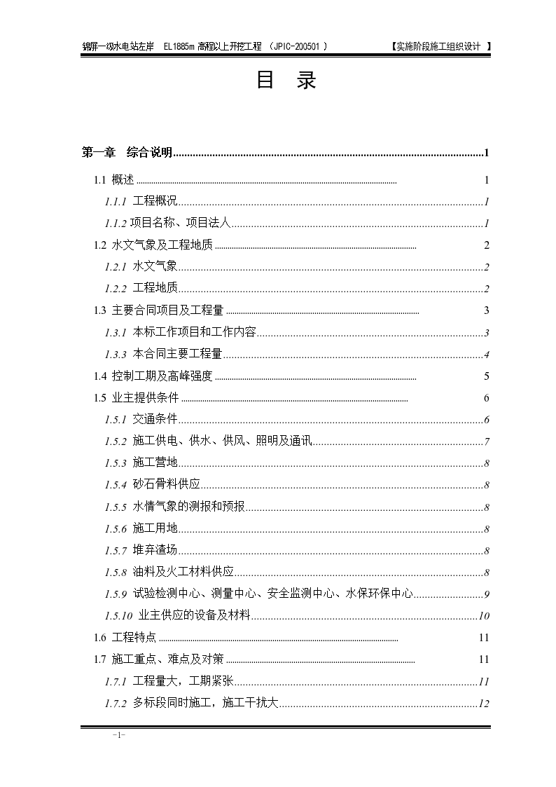
Construction organization design scheme for left bank excavation of a cascade I hydropower station

This document is: excavation of left bank of cascade I hydropower station Construction organization design scheme . The content is detailed and can be used for reference.

Uploader: Upload time: 2017-10-27 13:57:20 Document format: doc Number of collections: zero the number of pages: two hundred and ninety-six Comments: zero Category label: water conservancy project / Water conservancy project data / hydropower station
Detailed introduction Related recommendations Content comments
Detailed introduction
 Excavation construction organization design scheme for left bank of a cascade I hydropower station - Figure 1

Excavation construction organization design scheme for left bank of a cascade I hydropower station - Figure 1

Special statement: This material belongs to the sharing uploaded by users Downloaded content, only for learning, not for commercial use. If there is any copyright problem, please timely contact Station delete!

Collection
share

WeChat code scanning and sharing

Click to share

Related recommendations
  • [Xinjiang] Construction organization design of cascade I hydropower station
    The project is located in the Gobi hilly area in the north of TM in Wensu County, Aksu Prefecture, Xinjiang. The first stage station of TM I and II hydropower stations is located at the end of the diversion channel 15+463 of the first stage station. The main buildings include four parts: pressure forebay, pressure pipeline, powerhouse, flood discharge steep slope and some auxiliary structures. The building is of reinforced concrete structure. The fire resistance rating of the project is Grade II, the roof waterproof rating is Grade III, and the design service life is 50 years.
  • Civil construction organization on the left bank of Xiaowan Hydropower Station design scheme
    This document is the civil construction organization design scheme for the left bank of Xiaowan Hydropower Station. The content of the document is detailed for reference.
  • Concrete construction organization design of left bank dam of large hydropower station
    The length of the left bank Phase I dam along the dam axis is 344.92m, which is divided into the left bank riverbed dam section, the left bank slope dam section and the sand flushing hole dam section. The front edge of the river bed dam section on the left bank has a total length of 115.00m. There are 6 dam sections from left Africa ① to left Africa ⑥. Each dam section from left Africa ① to left Africa ⑤ is 20m wide, and the left Africa ⑥ is 15m wide. The river bed dam section is only poured to an elevation of 280.00m in the first phase of the project, forming a diversion gap of 115.00m wide for the flood control of the second phase of the project. A 10m × 14m diversion bottom outlet is reserved between the elevation of 260.00m~274.00m of the first stage sand flushing hole dam section and the left Africa ⑤ dam section.
  • Construction on the left bank of Xiaowan Hydropower Station design scheme
    The dam site of Xiaowan Hydropower Station is located in the middle reaches of Lancang River. The overall flow direction of rivers in the project is from north to south. In dry season, the river surface elevation is about 990m, the river surface width is 80m120m, the water depth is about 10m (before Manwan Reservoir impoundment), and the river valley basically presents a "V" shape. The rock property of dam foundation is mainly composed of metamorphic rocks such as biotite granite gneiss and hornblende plagioclase gneiss. The rock stratum is in monoclinic structure, with the occurrence of N7585W and NE7590. Due to multiple tectonic activities, the fracture structural plane is relatively developed. The weathering of the rock mass at the dam site is mainly the uniform weathering of the surface layer. In fault zones, joint intensive zones, alteration zones and thick mica schist intercalations, local cystic weathering and intercalations weathering often occur. The burial depth of the bottom boundary of the strongly weathered rock mass on both banks is generally 10m~20m, and it can reach 26m locally on the right bank. There is generally no strongly weathered rock mass distributed in the riverbed. The burial depth of the bottom boundary of weakly weathered rock mass is generally 40m~50m, and it can reach 70m~88m locally. The riverbed is generally 23m~31.5m. The river valley in this section is deep, with a relative height difference of more than 1000 meters. The bank slope is steep, and the unloading effect of rock mass on the slopes on both banks is strong, and unloading cracks are developed. The general rule is that the ridge part is obviously larger than the gully part, and the high elevation part is larger than the low elevation part. The maximum height of the ridge is 90m, the maximum height of the gully is 55m, the maximum height of the low elevation part is 40m, and the maximum height of the high elevation part is 90m.
  • Civil engineering organization on the left bank of Xiaowan Hydropower Station design scheme
    The project department, as the site organization, is set up according to the decision-making level, management level and operation level. According to the content, construction characteristics and management objectives of the project, the decision-making level members are determined, and the management level functional departments and operation level teams are set up.
  • Civil engineering organization on the left bank of a Xiaowan Hydropower Station design scheme
    The chief engineer assists the project manager in charge of construction technology and technical management, is responsible for the overall construction scheme of the project and the decision-making of major construction technology, presides over the development of the overall construction schedule and technical measures for quality and safety, and is the main person responsible for the construction technology of the project.
  • Construction organization design of a river hydropower station in Shuicheng County
    According to the construction organization design of the first level hydropower station on a river in Shuicheng County, the first level hydropower station on xx River in Shuicheng County is located at a river reach about 20m upstream of the inlet of the sinkhole near xx River in xx Township, Shuicheng County. This river is the largest second level tributary on the left bank of xx River, the first level tributary on the right bank of Beipan River.
  • Construction organization design of hydraulic tunnel of Jinping I Hydropower Station
    This document is the construction organization design of the hydraulic tunnel of Jinping I Hydropower Station. The contents of the document are detailed and the data are available for reference. The Yalong River basin is located in the east of the Qinghai Tibet Plateau, adjacent to Dadu River and Jinsha River on the east and west sides, and bounded by the upper reaches of the Yellow River on the north. The basin belongs to the western Sichuan plateau climate zone, mainly affected by the upper westerly circulation and southwest monsoon, with distinct dry and wet seasons. The dry season is from November to April of the next year, with little rainfall, warm and dry climate, low humidity and large daily temperature difference. The rainy season is from May to October, with little sunshine, high humidity and small daily temperature difference. The flood in the basin is mainly caused by rainstorm, which usually occurs from June to September, mainly in July and August, with continuous rainfall, and the average annual flow is 1200m3/s.
  • [Xinjiang] Construction organization design of cascade I hydropower station
    The project is located in the Gobi hilly area in the north of TM in Wensu County, Aksu Prefecture, Xinjiang. The first stage station of TM I and II hydropower stations is located at the end of the diversion channel 15+463 of the first stage station. The main buildings include four parts: pressure forebay, pressure pipeline, powerhouse, flood discharge steep slope and some auxiliary structures. The building is of reinforced concrete structure. The fire resistance rating of the project is Grade II, the roof waterproof rating is Grade III, and the design service life is 50 years.
  • Construction organization design of hydraulic tunnel of Jinping I Hydropower Station/
    1. General construction layout plan JPIC-G200503-T-01 2. Gantt chart of general construction schedule JPIC-G200503-T-02 3. Network chart of general construction schedule JPIC-G200503-T-03 4. Profile of excavation procedure of access tunnel JPIC-G200503-T-04
  • Monthly Supervision Report of a Grade I Hydropower Station Project in Sichuan Province
    1. Construction of temporary bridge works downstream of the site traffic: the project has been completed. 2. Construction of Jianggou Ditch Water Treatment (Drainage Tunnel) Project: It mainly carries out flood control works and other sporadic works. 3. On site traffic engineering [2 #, 4 #, 5 # roads] project construction: mainly completed this month: 2 # road has been basically completed; Earth rock excavation and masonry retaining wall construction are under way for Highway 4 #; The foundation excavation of concrete retaining wall is under way for Highway 5 #, and the foundation acceptance stage is in progress.
  • Excavation and support of diversion tunnel on the left bank of Jinping I Hydropower Station
    Jinping I Hydropower Station is located on the main stream of the Dahewan of the Yalong River at the junction of Muli County and Yanyuan County, Liangshan Yi Autonomous Prefecture, Sichuan Province. It is the leading reservoir for hydropower cascade development in the lower reaches of the Yalong River from Kara to Hekou, 358km from the estuary, and about 75km from Xichang City. The hydroproject buildings of the Project are mainly composed of concrete double curvature arch dam (including plunge pool and second dam), right bank spillway tunnel, right bank water diversion and power generation system, switch station, etc. The maximum dam height of the double curvature arch dam is 305m, and the concrete volume of the dam body is about 4.96 million m3. The engineering grade is Grade I, and the main hydraulic structures are Grade I. The project adopts year-round cutoff cofferdam, tunnel diversion and year-round construction of foundation pit. One diversion tunnel is arranged on the left bank and one on the right bank. The diversion tunnel is arranged symmetrically on both banks, with double bends and the same cross section. The cross section is gate type, and its size is 15 × 19m (width × height). The length of the tunnel body on the left bank is 1214.359m, and the inlet and outlet elevations are 1638.50m and 1634.00m respectively; the diversion tunnel inlet transition section and outlet section are lined with 1.0~1.2m thick concrete; 0.6m thick concrete full section lining is adopted for Class II surrounding rock of tunnel body section, 0.8m thick concrete full section lining is adopted for Class III surrounding rock of tunnel body section before the plug, 0.6m thick concrete full section lining is adopted for Class III surrounding rock after the plug, and 1.2m thick concrete full section lining is adopted for Class IV and V surrounding rock. The overburden on the deep buried section of the diversion tunnel on the left bank is 250~350m thick, with a horizontal burial depth of 180~250m. The overburden on the inlet section is 50~100m thick, with a horizontal burial depth of 50~70m. The overburden on the outlet section is 50~80m thick, with a horizontal burial depth of 40~60m. According to the engineering geological profile of the diversion tunnel on the left bank, most of the tunnel body is Class III surrounding rock, with three large faults passing through it. The fault and its influence zone are about 142m long of Class IV and V surrounding rock.
  • Construction organization design of excavation project of a hydropower station
    Xiangjiaba Hydropower Station is the last step in the cascade development of Jinsha River. It is located in the lower reaches of Jinsha River at the junction of Sichuan Province and Yunnan Province. The left bank of the dam site is 4km away from Anbian Town, Yibin County, Sichuan Province, 33km away from Yibin City, and the right bank is 1.5km away from Shuifu County, Yunnan Province. The development task of the project is mainly to generate electricity, improve navigation conditions, combine flood control and sediment detention, give consideration to irrigation, and have the function of back regulation for the upstream cascade. This project is a first class large (1) project, and the project hub layout is composed of dam, powerhouse, ship lift and other buildings. From left to right, the dam water retaining structure is composed of the left bank non overflow dam section, scouring hole dam section, ship lift dam section, left bank powerhouse dam section, water release dam section and right bank non overflow dam section. The dam crest elevation is 384.00m, the maximum dam height is 162m, and the dam crest length is 909.26m; The water release dam section is located in the middle of the main river channel near the right bank. The flood discharge adopts the method of combined surface and central outlets. The middle and surface outlets are arranged at intervals. A total of 10 middle and 12 surface outlets are arranged. The total length of the front edge of the dam section is 248.00m. The ship lift dam section is located on the left side of the river channel. The dam section is 29.60m wide, and the dam block is 115.50m long along the axis of the ship lift. The center line of the ship lift is 90 ° orthogonal to the dam axis, and it is composed of five parts, namely, the upstream approach channel, the upper lock head, the tower section, the lower lock head and the downstream approach channel, with a total length of 1260m. The power house is located in the right bank underground and behind the left bank dam, with 4 units installed each, each with a unit capacity of 750MW, and a total installed capacity of 6000MW. The installation room of the power house behind the left bank dam is arranged in a three-dimensional intersection with the navigation buildings.
  • Construction organization design of excavation project of a hydropower station
    Xiangjiaba Hydropower Station is the last step in the cascade development of Jinsha River. It is located in the lower reaches of Jinsha River at the junction of Sichuan Province and Yunnan Province. The left bank of the dam site is 4km away from Anbian Town, Yibin County, Sichuan Province, 33km away from Yibin City, and the right bank is 1.5km away from Shuifu County, Yunnan Province. The development task of the project is mainly to generate electricity, improve navigation conditions, combine flood control and sediment detention, give consideration to irrigation, and have the function of back regulation for the upstream cascade. This project is a first class large (1) project, and the project hub layout is composed of dam, powerhouse, ship lift and other buildings. From left to right, the dam water retaining structure is composed of the left bank non overflow dam section, scouring hole dam section, ship lift dam section, left bank powerhouse dam section, water release dam section and right bank non overflow dam section. The dam crest elevation is 384.00m, the maximum dam height is 162m, and the dam crest length is 909.26m; The water release dam section is located in the middle of the main river channel near the right bank. The flood discharge adopts the method of combined surface and central outlets. The middle and surface outlets are arranged at intervals. A total of 10 middle and 12 surface outlets are arranged. The total length of the front edge of the dam section is 248.00m. The ship lift dam section is located on the left side of the river channel. The dam section is 29.60m wide and the dam block is 115.50m long along the axis of the ship lift. The center line of the ship lift is 90 ° orthogonal to the dam axis, and it is composed of five parts, namely, the upstream approach channel, the upper lock head, the tower section, the lower lock head and the downstream approach channel, with a total length of 1260m. The power house is located in the right bank underground and behind the left bank dam, with 4 units installed each, each with a unit capacity of 750MW, and a total installed capacity of 6000MW. The installation room of the power house behind the left bank dam is arranged in a three-dimensional intersection with the navigation buildings.
  • Construction organization design of a hydropower station hydroproject in Xinjiang (CAD drawing attached)
    The hydroproject buildings in the plant area mainly include the main power house, auxiliary power house, GIS switchyard, tailrace pond, tailrace channel, tailrace channel crossing structures (aqueducts and traffic bridges) and permanent access roads. The main powerhouse has a total length of 88.62m and a width of 22m. The turbine installation elevation is 1491.60m. Three 70MW and one 34MW water turbine generator units are installed in the plant, with a total installed capacity of 244MW. The tailrace has a total length of about 3717m, a total gradient of 1/1000 and a bottom width of 3m.
  • [Yunnan] Construction Organization Design of Slag Gathering Platform Project for Arch Shoulder Trench Excavation on the Left Bank of Hydropower Station
    The left bank arch shoulder trench excavation and slag collection platform project is a temporary facility in the overall construction process of XX Hydropower Station. The XX Project Department of the Hydropower Force of the People's Armed Police Force proposed the optimization plan of the project based on the design drawings of the project of East China Survey, Design and Research Institute, combined with the actual situation of the site, and fully understood the original design intent. On March 24, 2011, after the construction preparation group of XX Hydropower Station, the XX Hydropower Station Supervision Department of Three Gorges Development Company, and the XX Hydropower Force of the People's Armed Police Force The project department jointly demonstrated and passed the optimization scheme. The slag collection platform is mainly composed of the following three parts: 1. the slag collection platform for dam abutment groove excavation (referred to as platform 1); 2. the slag collection platform for construction formed by the excavation of the slag collection platform adjacent to the dam abutment groove against the mountain (referred to as platform 2); 3. the slag collection platform for widening the road surface about 300m downstream along road 701 # (referred to as platform 3). Platform 3 uses concrete retaining wall to widen the 300m downstream section of 701 # road by 30m. The length of the concrete retaining wall is about 325m. The foundation elevation is determined as ▽ 616m~▽ 618m according to the terrain. The chance of being scoured by the flood is once in 10 years. The height of the concrete retaining wall is controlled at about 4~6m. The top of the retaining wall is controlled as ▽ 622m. It can be raised locally due to the bedrock conditions. After the concrete retaining wall is formed, the platform 3 can collect more than 200000 cubic meters of slag. Considering that the waste slag from dam abutment excavation cannot be directly dumped to the slag collection platform 3, it is proposed to excavate a temporary slag collection platform 2 between the downstream side of the dam abutment excavation scope and 503 # access tunnel as the temporary slag collection site for platform 1 excavation, which is about 60m long, 20m wide, 22m high, and about 23000m3 of excavation volume. Its specific scope will be determined by the Owner on site. Platform 1 is about 130m in east-west direction and 172m in south-north direction, with a total area of more than 20000 square meters. Within the excavation scope, there are buildings and structures such as power transformation and distribution rooms, poles, high-voltage cables, and abandoned concrete platforms. The excavation bottom elevation is from ▽ 693m to ▽ 793m, Due to the large drop, a multi-storey packway is arranged in the design drawing as the passage for backhoe excavator and loader construction. The excavated stone ballast is transferred to platform 3 through platform 2. After the platform 1 is formed, it will prepare for the formal excavation of earth and stone at the dam abutment.
  • Construction organization of left bank excavation project of a large hydropower station in Huzhou City design scheme
    Complete the procurement (excluding equipment and facilities provided by the Owner), calibration, installation, analysis, sorting and handover of observation and data during the construction period of the permanent safety monitoring engineering equipment and instruments shown in the construction drawings of the Contract
  • Hydraulic feasibility study design drawing of a hydropower station powerhouse in Qinghai

    The drawings include: 1. Cross section of powerhouse 2. Longitudinal section of powerhouse 3. Layout plan of powerhouse generator floor 4. Layout plan of powerhouse turbine floor

  • Civil construction on the left bank of Xiaowan Hydropower Station design scheme
    The dam site of Xiaowan Hydropower Station is located in the middle reaches of Lancang River. The overall flow direction of rivers in the project is from north to south. In dry season, the river valley in this bid section is deep, with a relative height difference of more than 1000 meters. The bank slope is steep, and the unloading effect of rock mass on the slopes on both banks is strong, with unloading cracks developed. The general rule is that the ridge part is obviously larger than the gully part, and the high elevation part is larger than the low elevation part. The maximum height of the mountain ridge is 90m, the maximum height of the gully is 55m, the maximum height of the low elevation is 40m, and the maximum height of the high elevation is 90m. According to the burial conditions and the nature of the water bearing space, the groundwater in the dam site area is mainly bedrock fissure phreatic water, and there is vein fissure confined water locally, followed by pore phreatic water and perched water in the Quaternary system. The whole dam foundation surface is dominated by slightly weathered un unloaded rock mass, and weakly weathered and unloaded rock mass is distributed at the high elevation of the dam foundation and the local section near the dam toe at the downstream of the dam foundation. Grade III fault F11, altered rock belt and many Grade IV structural planes are exposed on the foundation surface. There is no Grade III or above structural plane passing through the foundation surface of the dam foundation on the left bank, small faults f17, f19 and f30 are exposed on the thrust pier slope, and a small amount of unloading rock mass is distributed on the foundation surface.
  • Document of construction organization design for hydraulic tunnel of Jinping I Hydropower Station
    The Yalong River basin is located in the east of the Qinghai Tibet Plateau, adjacent to Dadu River and Jinsha River on the east and west sides, and bounded by the upper reaches of the Yellow River on the north. The basin belongs to the western Sichuan plateau climate zone, mainly affected by the upper westerly circulation and southwest monsoon, with distinct dry and wet seasons. The dry season is from November to April of the next year, with little rainfall, warm and dry climate, low humidity and large daily temperature difference. The rainy season is from May to October, with little sunshine, high humidity and small daily temperature difference. The flood in the basin is mainly caused by rainstorm, which usually occurs from June to September, mainly in July and August, with continuous rainfall, and the average annual flow is 1200m3/s.
  • [Xinjiang] Construction organization design of cascade I hydropower station
    Content introduction I. Foundation and foundation works (I) Earth excavation Before the commencement of the project, the site basically meets the requirements of "three supplies and one leveling". The geological structure of the site is complex, and dynamic compaction foundation treatment is required. This project is designed and constructed by Xinjiang Geotechnical Engineering Survey, Design and Research Institute. See the special construction scheme. Backhoe excavator shall be used for excavation of foundation pit earthwork. Excavation shall be carried out in layers, and the bottom shall be cleaned manually to avoid damage to the original soil. The next process can be carried out only after the concealed acceptance procedures have been handled... II. Construction method of main structure (I) The construction formwork of formwork engineering mainly adopts composite steel formwork or new glued large formwork. 1. The side formwork of the foundation cushion cap shall be combined steel formwork or wood formwork, and the formwork shall be combined horizontally or vertically according to the specific modulus... III. Concrete pouring 1 The construction site of concrete pouring sequence is narrow, the installation workload of electromechanical embedded parts is heavy, the civil construction and electromechanical construction are carried out alternately, and the construction interference is large.... VII. Embedded parts construction The equipment installation and equipment embedded parts construction of this project are all constructed by the manufacturer designated by the owner, and our project department carries out the setting out, reinforcement, formwork and other types of work in coordination with the construction, And prepare special construction scheme according to the drawings and specifications
  • Construction organization design scheme of hydraulic tunnel of cascade I hydropower station
    Project overview: the tunnel section of the contract project is 1229.446m long, that is, from 0+230.000 to K1+459.446. The tunnel is square and round, and the typical section size is 12m × 10m. The tunnel has three typical structural sections: A, B and C. Among them, the factory handover 0+230.000~factory handover 0+444.298 and factory handover 0+474.298~factory handover 0+844.414 are type A sections, factory handover 0+474.298~factory handover 0+444.298 are type C sections, and factory handover 0+964.414~factory handover K1+459.446 are type B. All construction items of the access tunnel project include excavation, support, concrete pouring, grouting, drainage, reinforcement fabrication and installation of the stonework tunnel. Among them, the owner reserves the right to adjust the implementation time of the tunnel floor concrete (pavement concrete) according to the changes of the relevant design contents of the underground powerhouse. However, the Tenderer shall still make no adjustment
  • Construction organization design document of a river hydropower station in Shuicheng County
    The first stage hydropower station of xx River in Shuicheng County is located at the reach about 20m upstream of the inlet of the Luoshuidong near xx River in xx Township, Shuicheng County. This river is the largest second stage tributary on the left bank of xx River, the first stage tributary on the right bank of Beipan River. The power station is the first cascade power station in the river reach, about 170km from Shuicheng County and 430km from Guiyang, which can be reached from Guiyang along the 320 National Highway through Anshun, Qinglong and Pu'an County. The power station is a diversion type high head power station, with a planned installed capacity of 2 × 12500kw, a power generation head of 390m, and a distance of about 7km from xx Township. The power supply scope of the first stage power station of xx River is in xx, Shunchang, Yezhong Township and other areas with outstanding power shortage. The main buildings of cc bid section (xx~xx bid section) of cascade I hydropower station on xx river include xx, discharge chute, pipe slope (anchor block, buttress), xx, booster station and other buildings. Xx is close to the tunnel outlet, 29.16m long, 18.2m wide, 8.35m maximum water depth, 1262.92m normal water storage level, 1263.99m maximum water level, 1255.64m bottom plate elevation of xx, 1263.02m overflow weir top elevation. The discharge chute is located on the right side of xx, close to the overflow weir, 274.43m long, rectangular section, 1.5m × 2m section size, crossing the dam road (i.e. 1 # highway bridge and culvert) at 0+061.73~0+075.43 section. The pipe slope (penstock) is located directly in front of xx, next to the xx drain gate, with a length of 1127.93m, the bottom width of the pipe trench excavation of 5.3m, the diameter of the steel pipe φ=1.6m, and the average slope of the pipe slope of 19 °. There are 12 anchor blocks and several buttresses, of which 3 # and 4 # anchor blocks and the buttresses between 3 # and 5 # anchor blocks are cast-in-place pile foundations, with a single hole diameter of 600mm and an average hole depth of 9-12m, The pipe slope crosses the dam access road (i.e. 2 # highway bridge and culvert) at 0+070~0+089. Xx is ground type, located in the gully 150 m downstream of the road on the right bank of xx River Bridge, about 20 m away from the road, and the tailwater flows through the road into the xx River tunnel (i.e. the tailwater highway bridge and culvert), Xx is arranged vertically in the river. The main xx is 36.5m × 15m × 18m in size (length × width × height), and the generator floor is 890.77m in elevation. The auxiliary xx is located on the right side of the main xx, next to the main xx, and is arranged in two layers. The design size (length × width × height) is 16.14 × 16.5m × 10m. The switch station is located on the right side of the auxiliary xx, next to the auxiliary xx, and the design size (length × width) is 12.75 × 16.5m,
  • Construction organization design of hydraulic tunnel of Jinping I Hydropower Station
    The Yalong River basin is located in the east of the Qinghai Tibet Plateau, adjacent to Dadu River and Jinsha River on the east and west sides, and bounded by the upper reaches of the Yellow River on the north. The basin belongs to the western Sichuan plateau climate zone, mainly affected by the upper westerly circulation and southwest monsoon, with distinct dry and wet seasons. The dry season is from November to April of the next year, with little rainfall, warm and dry climate, low humidity and large daily temperature difference. The rainy season is from May to October, with little sunshine, high humidity and small daily temperature difference. The flood in the basin is mainly caused by rainstorm, which usually occurs from June to September, mainly in July and August, with continuous rainfall, and the average annual flow is 1200m3/s.
  • Construction organization design of a river hydropower station in Shuicheng County
    The first stage hydropower station of xx River in Shuicheng County is located at the reach about 20m upstream of the inlet of the Luoshuidong near xx River in xx Township, Shuicheng County. This river is the largest second stage tributary on the left bank of xx River, the first stage tributary on the right bank of Beipan River. The power station is the first cascade power station in the river reach, about 170km from Shuicheng County and 430km from Guiyang, which can be reached from Guiyang along the 320 National Highway through Anshun, Qinglong and Pu'an County. The power station is a diversion type high head power station, with a planned installed capacity of 2 × 12500kw, a power generation head of 390m, and a distance of about 7km from xx Township. The power supply scope of the first stage power station of xx River is in xx, Shunchang, Yezhong Township and other areas with outstanding power shortage.
  • Jinping I Hydropower Station Hydraulic Tunnel Construction Organization Design.doc
    The Yalong River basin is located in the east of the Qinghai Tibet Plateau, adjacent to Dadu River and Jinsha River on the east and west sides, and bounded by the upper reaches of the Yellow River on the north. The basin belongs to the western Sichuan plateau climate zone, mainly affected by the upper westerly circulation and southwest monsoon, with distinct dry and wet seasons. The dry season is from November to April of the next year, with little rainfall, warm and dry climate, low humidity and large daily temperature difference. The rainy season is from May to October, with little sunshine, high humidity and small daily temperature difference. The flood in the basin is mainly caused by storm ...
  • Electrical preliminary design drawing of a cascade I hydropower station project in Sichuan Province

    35kV booster station bay section diagram, 35kV booster station electrical general layout, protection device, measurement, synchronization configuration single line diagram, auxiliary power wiring scheme diagram, electrical main wiring, power station microcomputer monitoring system diagram, auxiliary power house layout, fire alarm system diagram, DC system diagram

  • Construction organization design of left bank slope excavation and support works of a hydropower station on Wujiang River
    Content introduction 1.1 Basic information of the project xx Hydropower Station is located in the lower reaches of the Wujiang River, Wulong County, Chongqing. It is the eleventh cascade of hydropower development planning in the main stream of the Wujiang River. The upstream is connected to Pengshui Hydropower Station, and the downstream is the planned Baima cascade. It is a pivotal project that takes into account the reverse regulation task of Pengshui Hydropower Station and channelization of waterways. The development task of the project is mainly to generate electricity, followed by shipping. According to the development tasks and functional requirements of the project, xx hydropower station hub is mainly composed of water retaining structures, flood discharge structures, power plant and navigation structures. The dam site is open, and the rock stratum is mainly shale, sandstone and limestone; The flood flow is large, and the power generation head of the power station is low; According to the topographic, geological and hydrological conditions, the construction scheme of concrete gravity dam, river bed powerhouse and staged diversion is adopted. The normal pool level of xx Hydropower Station is 215.00m, the total storage capacity is 320 million m3, the maximum dam height is 76.5m, the installed capacity of the power station is 600MW (4 × 150MW), and the scale of navigation building is 500t single stage ship lock. According to the Flood Control Standard (GB50201-94) and the Classification and Design Safety Standard for Hydropower Projects (DL5180-2003), the project is classified as Grade II, the project scale is large (2), the main buildings (concrete gravity dam, power house) are Grade II buildings, and the secondary buildings are Grade III buildings; According to the Code for Design of Hydraulic Structures of Ship Locks (JTJ307-2001), the proposed ship lock level is: the upper lock head, lock chamber and lower lock head are Level 2 buildings, and the navigation facilities and berthing piers of the ship lock are Level 4 buildings. The scope of this bidding includes the excavation and support construction of the left bank dam abutment with an elevation of more than 181m, the tailrace phase I, and the construction of the reconstruction section (temporary) of Highway 4 #. The left bank abutment slope is excavated to an elevation of 181.00m this time, with the maximum excavation slope height of about 120.00m. The permanent slope is excavated and supported above the elevation of 227.5m, and the temporary slope is excavated and supported below the elevation of 227.5m. On the left side of the tailrace is the tailrace slope, with the maximum excavation slope height of about 100.00m. The plant access road is arranged at an elevation of 226.00m above the slope. The upstream end of the road is connected to the tailrace platform and the dam access road in Section I of An'an, and the downstream end is connected to National Highway 319. The excavation gradient of permanent slope is 1:1 for strong weathering, 1:0.8 for weak weathering and 1:0.5 for slightly new rock. A 3m wide berm is set every 15m on the slope. Permanent slope reinforcement measures mainly include shotcrete with wire mesh, anchor bolt, prestressed anchor cable, reinforced concrete slope protection, anti sliding key, slope surface drainage and slope body drainage, etc. Meanwhile, slope deformation monitoring is strengthened.
  • Construction design of hydraulic tunnel of Jinping I Hydropower Station
    For the air supply system, the access tunnel to the plant in this bid is mainly excavated by three arm drill, and shotcrete and anchor support are carried out by anchor rod jumbo and wet shotcrete jumbo. The air supply part for construction is mainly for support and excavation in poor geological conditions. It is proposed to arrange an air compressor station near the entrance of the traffic tunnel of Jinxi Bridge, and install three 20m3/min electric air compressors with a total air supply of 60m3/min.
  • Organization scheme for hydraulic tunnel of Jinping I Hydropower Station
    (3) High pressure air shall be used to flush the hole before charging the charging line, and charging blasting can be carried out only after the blast hole is checked to be qualified; The charging and blocking of blast holes and the connection of detonating lines shall be carried out by qualified blasters in strict accordance with the approved drilling and blasting design, and the charging shall strictly comply with the blasting safety operation regulations. Skilled gunners are responsible for charging the cutting holes, and small cartridges are used to bind the smooth blasting holes and presplitting holes on the bamboo slices for interval charging. The hydraulic elevating platform truck is used as the climbing equipment for charging. The charging of the cutting hole, expanding hole and other blasting holes shall be dense and well blocked. The charging shall be carried out in strict accordance with the blasting design drawing (the implementation process of blasting parameters shall be continuously adjusted and optimized), and the detonating network shall be connected with non electric detonators. At last, the blaster and the technician on duty shall recheck and check to confirm that there is no error, and evacuate personnel and equipment, The gunner is responsible for detonating.
  • Construction organization design of large hydropower station dam excavation project
    Project overview xxx hydropower station is located at xx, 1.5km upstream of xxx estuary in Yuqing County, Guizhou Province. The upstream is 137km away from xxx hydropower station, and the downstream is 455km away from Fuling at the estuary. The controlled drainage area is 43250km2, and the average annual runoff is 22.6 billion m3. The main task of project development is to generate electricity, and take into account shipping, flood control and other comprehensive utilization. The total storage capacity of the reservoir is 6.451 billion m3, the regulating storage capacity is 3.154 billion m3, and the normal pool level is 630 m. The installed capacity of the power station is 3000 MW, the guaranteed output is 751.8 MW, and the annual power generation is 9.667 billion kw · h. It is the largest hydropower power source in Guizhou Province and the main stream of xxx.
  • Construction of hydraulic tunnel of Jinping I Hydropower Station
    The Yalong River basin is located in the east of the Qinghai Tibet Plateau, adjacent to Dadu River and Jinsha River on the east and west sides, and bounded by the upper reaches of the Yellow River on the north. The basin belongs to the western Sichuan plateau climate zone, mainly affected by the upper westerly circulation and southwest monsoon, with distinct dry and wet seasons. The dry season is from November to April of the next year, with little rainfall, warm and dry climate, low humidity and large daily temperature difference. The rainy season is from May to October, with little sunshine, high humidity and small daily temperature difference. The flood in the basin is mainly caused by rainstorm, which usually occurs from June to September, mainly in July and August, with continuous rainfall, and the average annual flow is 1200m3/s.
  • Construction organization design of a hydropower station in Sichuan
    Xx Hydropower Station, located in xx County and xx County of xx Province, is the leading (reservoir) power station for cascade hydropower development of Nanya River. The power station complex is composed of asphalt concrete core rockfill dam, left bank spillway tunnel and vent (and diversion) tunnel, power generation diversion tunnel, surge shaft, penstock, underground powerhouse and other buildings. The maximum dam height of the rockfill dam is 125.5m; the length of the flood discharge tunnel is 641.88m, and the lining section is 6 × 8.5m or 6 × 6m; the length of the emptying tunnel is 1072.9m, the front section is round, the inner diameter of the lining is 4m, the rear section is square and round, and the lining section is 5.5 × 4.5m; the length of the power generation diversion tunnel is 7118.8m, and the section is round or square and round 4.6 × 4.6m; the total length of the upper chamber of the surge shaft is 250.0m, and the maximum height of the shaft is 85m; the length of the pressure pipeline is 1861.416m, The diameter of the main pipe is 3.4m; two water turbine generator units are installed in the underground powerhouse, with a unit capacity of 120MW and a total installed capacity of 240MW.
  • Dam construction organization design of a hydropower station
    XXXX Hydropower Station is located on the Getu River, the main stream of XXXX, with the administrative division of XXXXX, 18km away from the confluence of XXXXX and the tributary Lianjiang River (XXXX). It is the third cascade hydropower station on the main stream of XXXXX. The installed capacity of the power station is 2 × 27MW, the normal pool level of the reservoir is 795.5 m, the corresponding storage capacity is 162.8 million m3, the dead water level is 770 m, the dead storage capacity is 79.9 million m3, and the effective storage capacity is 82.9 million m3. The power station hub is composed of the dam, power generation diversion tunnel, powerhouse, sand flushing bottom outlet, switch station and other major buildings. The dam is a roller compacted concrete double curvature arch dam, with the maximum dam height of 110m, dam crest elevation of 800m, dam crest width of 6m, dam crest arc length of 287.625m, dam bottom maximum width of 26.5m, and dam thickness height ratio of 0.24.
  • Construction organization design of a hydropower station in Hubei
    A certain hydropower station is located on Nanhe Fenqing River, a tributary on the right bank of the middle reaches of Han River in a certain county, Hubei Province, 5 km away from a certain town, and 102.4 km away from the estuary. The project is a large (II) type project, which focuses on power generation and has comprehensive utilization benefits of flood control, irrigation, aquaculture, and shipping in the reservoir area. The normal pool level of the reservoir is 315.00m, the total storage capacity is 269 million m3, the installed capacity of the power station is 60MW, and the annual power generation is 179.2 million kW. h. A certain hydropower station is composed of concrete face rockfill dam, right bank spillway, right bank diversion type ground powerhouse, etc. The main buildings are classified as Level 2, and the secondary buildings are classified as Level 3. The main building of this section is the spillway. The spillway is located in Dafan Pass, with flat terrain on both sides. The ground elevation is 300~340 m, and the natural slope is about 1:2. Spillway is composed of 4 parts: approach channel, gate chamber section, chute section and flip bucket section.
Click to see more
All comments I want to comment
No comment