Web Game Opening Sheet - 9K9K COM age appropriate tip: it is recommended to be over 18 years old
Current location: Home page  >  APP application market  >  Google Maps Official Edition
Google Maps Official Edition
 Google Maps Official Edition

Scan and download with mobile phone

  • 360 test
  • Tencent housekeeper
Application Introduction

The official version of Google Maps, a world-class popular navigation software, not only has the most accurate navigation in the world, but also has practical information such as destination information, traffic information, etc. It also has Chinese services so that Chinese people no longer worry about finding a destination when going out. It is undoubtedly the best choice for tourists to guide Google Maps abroad.

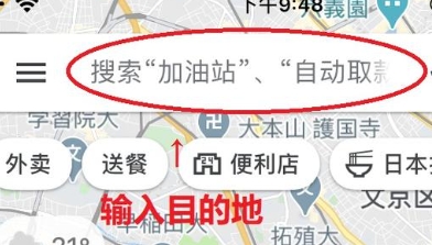
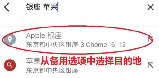
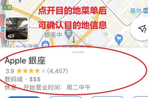
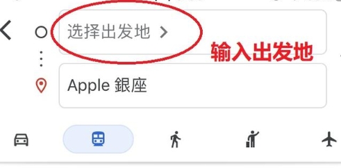
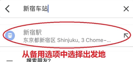
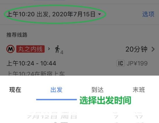
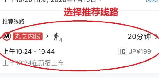
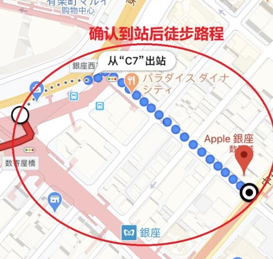
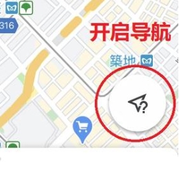
Detailed use tutorial of Google Maps app

① Download and open Google Maps App.

② Enter the destination.

③ Select a destination from the alternative options below the input field.

④ The destination coordinates will appear on the map. Open the menu at the bottom of the screen to view the destination details.

⑤ Select "Route" after confirming the destination details.

There are a lot of practical information about the destination details here, such as business hours, telephone, home page, photos, store reviews, etc., and they are basically automatically translated into Chinese, which is very convenient!

⑥ Enter the starting place, or select "Current position"

★ The current position needs to enable the positioning setting.

⑦ Select the origin from the alternative options below the input field.

⑧ Select the mode of transportation to use and the departure time.

Transportation options: driving, public transportation (tram, bus, etc.), walking, taxi.

⑨ Departure time is optional: departure time, arrival time, departure time and last bus.

⑩ When selecting a recommended route and multiple trams can reach it, there will be multiple alternative options. Generally, the recommended route of Google Maps will be selected.

At the same time, you can confirm the tram departure, arrival time, fare and other information on this page.

⑪ Click the route to view more detailed distance information. Click "Walk" after confirmation to confirm the walking distance after departure.

For example, other routes, the nearest tram exit from the destination (very necessary in Japan), etc.

Recommend screenshots when doing homework for travel.

⑫ Confirm the nearest exit and hiking distance.

⑬ Turn on navigation at departure.

★ Navigation needs to open positioning settings.

Software features

1. Google Maps is very rich in data, and has added the latest AI artificial intelligence to help you navigate better.

2. Concise and clear, without any redundant interface, it injects soul and vitality into traditional electronic maps.

3. Combining navigation and immersive view modes allows users to preview routes at a more personalized level.

Software advantages

1. The software has collected billions of street view images and satellite images, presenting a lifelike three-dimensional landscape.

2. It can help you quickly identify the surrounding environment, which is very suitable for traveling to strange places or exploring new communities.

3. Just click the lens icon in the search bar, and then hold up your mobile phone to find the surrounding ATM and subway stations.

Application screenshot
  •  Official screenshot of Google Maps
  •  Official screenshot of Google Maps
  •  Official screenshot of Google Maps
  •  Official screenshot of Google Maps
  •  Official screenshot of Google Maps
Same type
Latest information