
Ovi Interactive Map Browser PC version 32/64 bits
-
Software size: 52 MB -
Software language: Simplified Chinese -
Updated: 2024-04-22 -
Software type: Domestic software/transportation -
Operating environment: WinAll, WinXP, Win7, Win10 -
Software license: freeware -
Official homepage: http://www.ovital.net/ -
Software level:

SkyDemon (navigation software) v3.16.13.93 free version 
Google Lunar High Definition Satellite Map v5.0 Chinese Free Edition -
Ovi Interactive Map Green Chinese Version v8.7.7 Computer Version 
Official version of bigemap high-definition satellite map 
Google Satellite Map Downloader official v29.6.3.0 latest version 
Google Satellite Map HD latest v25.6.0.0 green version
-
Introduction -
Download address -
Boutique recommendation -
Related software -
Netizen comments
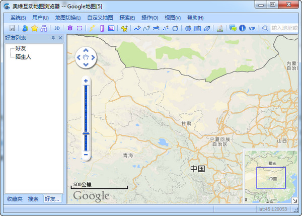
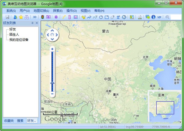
Ovi Interactive Map Browser PC Edition Introduction:
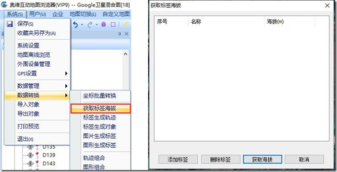
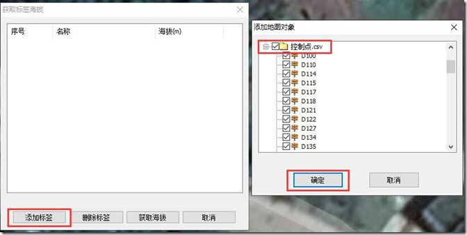
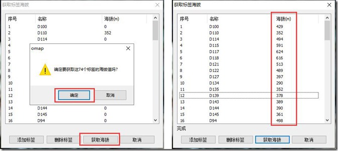
Ovi Interactive Map Browser PC client function:
Software features:
common problem:

Update log
Download address
-
Pc version -
Android -
IPhone version
Ovi Interactive Map Browser computer version 32/64 bit v9.9.8 official latest version
Boutique recommendation
-
Ovi Interactive Map

Ovi Interactive Map More+
-
Ovi Interactive Map Browser ios v9.3.1 iPhone 100.00 MB / Simplified Chinese V9.3.1 iPhone version download -
Ovi Interactive Map Express v9.6.5 Android 79.3 MB / Simplified Chinese v9.6.5 download -
Ovi Interactive Map Browser computer version 32/64 bit v9.9.8 official latest version 52 MB / Simplified Chinese V9.9.8 Official latest version download -
Ovi Interactive Map Green Chinese Version v8.7.7 Computer Version 26.00 MB / Simplified Chinese V8.7.7 Computer Edition download -
Ovi Interactive Map 8.0.5 v9.6.5 Android 79.3 MB / Simplified Chinese v9.6.5 download -

Ovi Interactive Map App Free v28 Android 67.72 MB / Simplified Chinese v28 download -
Google Ovi Interactive Map Browser v9.6.5 Android 79.3 MB / Simplified Chinese v9.6.5 download -
Ovi interactive map old version v7.9.5 Android version 25.76 MB / Simplified Chinese V7.9.5 Android download
Netizen comments
-
Bozhou, Anhui - Aurora download netizen Published on: December 30, 2020 21:11:21 -
Very good navigation map, easy to use, I really like it. Support( three ) reply
Ranking in this category
-
one Kailide car navigation map upgrade package v2.0.4.0 -
two Content manager launcher v2023 official version -
three Understanding Chedi's official version of v6.9.3 -
four Official version of offline map data package of Gaode Map -
five Shenzhen Metro 2030 Latest Planning (HD) Ultimate -
six Kailide navigation upgrade 2019 v2.0.4.0 -
seven Kailide mobile navigation system c-car version v6.0 official version -
eight Ovi Interactive Map Browser computer version 32/64 bit v9.9.8 official latest version -
nine Sogou map pc version v10.6.5 computer version -
ten Tencent map pc version v9.3.0 official version
This category of recommendation
-
one Ovi Interactive Map Browser computer version 32/64 bit v9.9.8 official latest version -
two Guizhou Traffic Police PC Version v5.91 Computer Version -
three Xinlan 12306 Ticket Booking Assistant v1.0.0.3095 Official Latest Version -
four Sogou map pc version v10.6.5 computer version -
five Google Earth Pro Computer Version v7.3 Official Version -
six Google earth computer installation package v7.3.3 pc latest version -
seven Feixiang parking lot charging software computer version -
eight Shouqi Car hailing PC Version v8.0.28 Latest Version -
nine Tencent map pc version v9.3.0 official version -
ten Mapwise Computer Version v1.1.4 Official Version


Necessary for installation
-

WinRAR official 64 bit -

Google Chrome -

ITunes 32-bit -

Sogou Pinyin Input Method Computer Version -

Kugou Music Player PC Edition -

360 security guard computer version -

IQIYI pps video client -

Baidu online disk PC version -

Tencent Computer Housekeeper Win10 Special Edition -

WeChat 2024 latest computer version -

Tencent app pc -

Wps office 2016 professional edition


-
chat -
Qq computer version -
WeChat computer version -
Yy voice -
skype -
video -
Tencent Video -
IQIYI -
Youku Video -
Mango tv -
clip -
Love editing -
Cut and reflect -
Ulead VideoStudio -
adobe premiere -
music -
Qq music -
NetEase cloud music -
Cool dog music -
Kuwo Music -
browser -
360 Browser -
Google Browser -
Firefox -
Ie browser -
to work in an office -
Nail -
Enterprise WeChat -
wps -
office -
typewriting -
Sogou input method -
Qq input method -
Five stroke input method -
iFlytek Input -
compress -
360 Compression -
winrar -
winzip -
7z decompression software -
translate -
Google Translate -
Baidu Translate -
Jinshan Translation -
English to Chinese software -
Anti-Virus -
360 Antivirus -
360 Security Guard -
Tinder software -
Tencent Computer Housekeeper -
P diagram -
Beautiful pictures -
photoshop -
nEO iMAGING -
lightroom -
programming -
python -
C language software -
Java development tools -
vc6.0 -
Online disk -
Baidu online disk -
AliCloud disk -
115 network disk -
Celestial wing cloud disk -
download -
Thunder -
Qq cyclone -
Emule -
utorrent -
negotiable securities -
Huatai Securities -
gf securities -
Founder Securities -
Southwest Securities -
mailbox -
Qq mailbox -
outlook -
Alibaba Email -
icloud -
drive -
Drive sprite -
Drive life -
Network card driver -
Printer drive