
Latest version of real-time altimeter
-
App size: 3.13 MB -
Application language: Simplified Chinese -
Updated: 2020-12-18 -
Application type: Domestic software/integrated software -
Operating environment: Android -
Application level: -
Official homepage: http://www.xz7.com/
-
Introduction -
Download address -
Boutique recommendation -
Related software -
Netizen comments
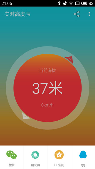
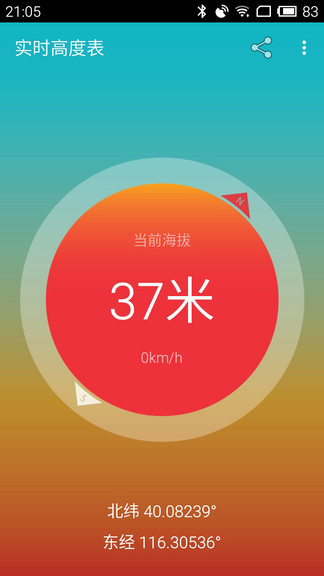
Introduction to the latest version of real-time altimeter:

Features of real-time altimeter app:
Application highlights:
Updated content:
Download address
-
Android
Latest version of real-time altimeter v2.1.1 Android version
Boutique recommendation
-
Longitude and latitude app -
Angle measurement software -
Measurement app
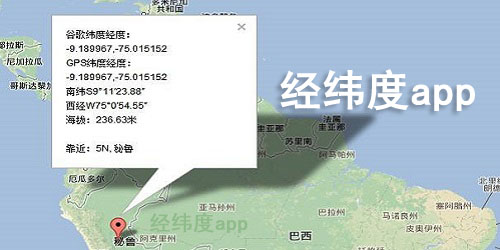
Longitude and latitude app More+

Longitude and latitude positioning query software v7.0.5 54.3 MB / Simplified Chinese v7.0.5 download 
Gps real-time altitude satellite map latest version v1.82 35.1 MB / Simplified Chinese v1.82 download Latest version of real-time altimeter v2.1.1 Android version 3.13 MB / Simplified Chinese V2.1.1 Android download 
Latest version of gps altimeter v3.2 27.6 MB / Simplified Chinese v3.2 download 
Gps altimeter app v3.2 39.8 MB / Simplified Chinese v3.2 download 
Latitude and longitude altitude software v1.2.1 Android latest version 2.30 MB / Simplified Chinese V1.2.1 Latest version of Android download 
Longitude and latitude query and conversion app v1.0.60 36.8 MB / Simplified Chinese v1.0.60 download
Angle measurement software More+

Distance measuring instrument app v2.5.58 135.8 MB / Simplified Chinese v2.5.58 download 
Engineering Star Mobile v1.02.180713 Android 15.00 MB / Simplified Chinese V1.02.180713 Android download 
Measurement tool mobile version v4.5.6 33.3 MB / Chinese version v4.5.6 download 
China Lubanchi Software v1.0.8 16.1 MB / Simplified Chinese v1.0.8 download 
Ar Measurement Assistant app v1.0.8 Android 5.45 MB / Simplified Chinese V1.0.8 Android download 
Xiaobai spirit level mobile v1.0 Android 4.34 MB / Simplified Chinese V1.0 Android download 
The latest version of Master Surveyor v2.62.5 82.1 MB / Simplified Chinese v2.62.5 download 
Professional measuring ruler software v2.5.6 Android version 1.35 MB / Simplified Chinese V2.5.6 Android download
Measurement app More+
Distance measuring instrument app v2.5.58 135.8 MB / Simplified Chinese v2.5.58 download Engineering Star Mobile v1.02.180713 Android 15.00 MB / Simplified Chinese V1.02.180713 Android download Measurement tool mobile version v4.5.6 33.3 MB / Chinese version v4.5.6 download China Lubanchi Software v1.0.8 16.1 MB / Simplified Chinese v1.0.8 download Ar Measurement Assistant app v1.0.8 Android 5.45 MB / Simplified Chinese V1.0.8 Android download Xiaobai spirit level mobile v1.0 Android 4.34 MB / Simplified Chinese V1.0 Android download The latest version of Master Surveyor v2.62.5 82.1 MB / Simplified Chinese v2.62.5 download Professional measuring ruler software v2.5.6 Android version 1.35 MB / Simplified Chinese V2.5.6 Android download
Related software
Netizen comments
Guess you like it


Popular in this category
Popular Collections
-
download 
Tmall Genie mobile version v8.4.1 125.1 MB / 2024-02-26 -
download 
Baidu browser app v5.39.5.30 42.9 MB / 2023-04-20 -
download 
Wukong remote control app v3.9.8.406 Android version 21.88 MB / 2022-02-03 -
download 
The latest version of Mickey Man's browser, appv5.5.4, official Android version 2.12 MB / 2021-06-27 -
download 
The latest version of the location software v13.1.19 for Tianxia Travel 23.15 MB / 2021-02-26 -
download 
Double opening butler app v1.6.4 Android 6.19 MB / 2020-12-15 -
download 
Free Space app v1.0.2060 Android 3.90 MB / 2020-12-15 -
download 
X avatar app v1.5.6 Android new version 17.60 MB / 2020-07-28 -
download 
WeChat dual partner app v3.1 Android free version 3.83 MB / 2018-11-21
This category of recommendation
-
one Doutu emoticon bag production latest version v2.2.39 -
two Official version of Oupeng browser v12.84.0.1 -
three Mobile phone Baidu 2023 new version v13.44.0.10 -
four Sogou browser appv14.1.5.5011 -
five Text to Speech Master app v2.0.0 -
six Baidu online disk mobile version v11.5.1.4 -
seven The latest version of uc browser app v15.3.2.1222 -
eight Expression Pack Daquan Mobile Version v2.1.9 -
nine Sogou Search Free Reading Fiction v12.2.4.2219 Android Free Edition -
ten Cheetah Browser 2018 v5.27.0 Android


Necessary for installation

Mobile WeChat app 
Mobile qq music app 
WiFi master key 
Latest version of today's headlines 2023 
Sogou IME 2022 latest version 
Mobile phone Kuwo music app 
Kingsoft PowerWord Mobile Edition 
Ink Weather Mobile Edition 
Meituan group purchase app 
Baidu Maps app 
Railway 12306 ticket booking software 
Rebate website app


-
chat -
Mo Mo -
Mobile WeChat -
Mobile qq -
Exploration -
video -
Youku Video -
Tencent Video -
Mango tv -
IQIYI -
clip -
Ulead VideoStudio -
Love editing -
Powerful Director -
Cut and reflect -
music -
Kuwo Music -
Cool dog music -
NetEase cloud music -
Qq music -
browser -
360 Browser -
Ie browser -
Firefox -
Google Browser -
to work in an office -
wps -
Enterprise WeChat -
Nail -
office -
typewriting -
Five stroke input method -
Sogou input method -
Qq input method -
iFlytek Input -
P diagram -
Beautiful pictures -
photoshop -
nEO iMAGING -
lightroom -
Online disk -
115 network disk -
Celestial wing cloud disk -
Baidu online disk -
AliCloud disk -
mailbox -
Alibaba Email -
Qq mailbox -
outlook -
icloud -
Journalism -
Today's headlines -
Tencent News -
Hupu app -
NetEase News -
novel -
Fei Lu's novels -
Book chasing artifact -
Biqu Pavilion -
Migu Reading -
comic -
Tencent Animation -
First round -
Buka Comics -
Comic Island app -
Photography -
Watermark camera -
Daily p chart -
B612 camera -
Yitian Camera -
online shopping -
Idle fish -
Tmall app -
JD app -
Pinduoduo -
education -
Hujiang app -
Safety education platform -
Good score -
Seven day network -
healthy -
Vaccine app -
Yoga app -
Beauty app -
Registered app