The latest version of South Cass
-
Software size: 434 MB -
Software language: Simplified Chinese -
Updated: 2023-11-14 -
Software type: Domestic software/auxiliary design -
Operating environment: WinAll, WinXP, Win7, Win10 -
Software license: freeware -
Official homepage: http://www.xz7.com -
Software level:
Scan2CAD (picture to CAD software) v10.4.13 free version 
Zhongwang Structural CAD Software Download v2023 Official Version 
Zhongwang CAD software 32/64v2023 official version 
LeoCAD software (Lego model production) v21.06 official version -
Southern Cass5.1 official computer version -
Southern cass9.2 installation package 32&64 bit Chinese version
-
Introduction -
Download address -
Boutique recommendation -
Related software -
Netizen comments
| ||
| | | |
| | | |
| | | |
| | | |
| | | |
| | ||
Introduction to the latest version of South Cass
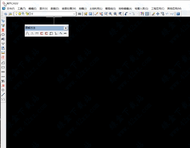
Features of south cass software
Installation Tutorial
South cass shortcut key command
Download address
-
Pc version
The latest version of South Cass v11.0.0.8 official version
Boutique recommendation
-
Cad editing tools -
South cass -
Quantity takeoff software

Cad editing tools More+

Acadtools computer version v4.0 official version 648.00 KB / Simplified Chinese V4.0 official version download 
The latest free version of autocad v4.6.10 Android Chinese 31.57 MB / Simplified Chinese V4.6.10 Android Chinese download 
Freecad mac version official version 226.10 MB / Simplified Chinese Official edition download Freecad Chinese version v0.14.3700 genuine 121.50 MB / Simplified Chinese V0.14.3700 genuine download 
3D CAD View Computer Version Latest Version 52.25 MB / Simplified Chinese the latest version download 
Official version of cad minidrawing v2021 latest version 35.42 MB / Simplified Chinese V2021 latest edition download 
Autocad electrical computer version v29.46.1 Chinese version 2.00 KB / Simplified Chinese V29.046.1 Chinese version download 
Haochen 3d2021 official v2021 latest version 3.80 GB / Simplified Chinese V2021 latest edition download

South cass More+

South cass9.1 software installation package 32&64 bit official version 64.60 MB / Simplified Chinese 32&64 bit official version download The latest version of South Cass v11.0.0.8 official version 434 MB / Simplified Chinese V11.0.0.8 Official Version download South Cass10.0 official computer version 330.00 MB / Simplified Chinese Computer version download South Cass11.0 latest official version 434 MB / Simplified Chinese Official edition download Southern cass8.0 installation package computer version 36.00 MB / Simplified Chinese Computer version download South cass6.0 Chinese installation package official version 36.65 MB / Simplified Chinese Official edition download Southern Cass10.0 Perfect Cracking Version v10.0 Computer Version 396.00 MB / Simplified Chinese V10.0 PC download Southern Cass 6.1 Chinese version Computer version 36.65 MB / Simplified Chinese Computer version download
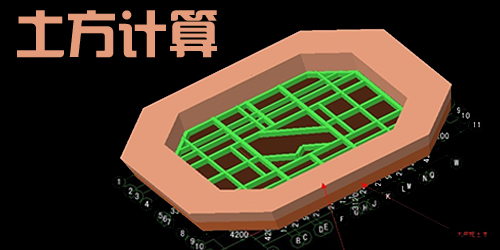
Quantity takeoff software More+

Road earthwork calculation expert software v5.2 green version 3.30 MB / Simplified Chinese V5.2 Green Edition download 
Earthwork Spirit Free Official Edition 295.00 KB / Simplified Chinese Official edition download 
Fasttft earthwork calculation software v11.1 free version 90.80 MB / Simplified Chinese V11.1 Free download 
Hongye earthwork calculation software v8.0 free version 140.30 MB / Simplified Chinese V8.0 Free download The latest version of South Cass v11.0.0.8 official version 434 MB / Simplified Chinese V11.0.0.8 Official Version download 
Tongwang project cost management software v10.5.0 official version 580.00 MB / Simplified Chinese V10.5.0 Official Version download 
Tea tasting bim construction planning software installation package v3.3.1.18106 official version 764.00 MB / Simplified Chinese V3.3.1.18106 Official Version download
Related software
-
Cass9.2 dog free cracking version v9.2 perfect cracking version View details 2021-08-12 77.95 MB -
Southern Cass10.0 Perfect Cracking Version v10.0 Computer Version View details 2021-03-10 396.00 MB -
Southern cass8.0 installation package computer version View details 2020-09-10 36.00 MB -
Southern cass9.2 installation package 32&64 bit Chinese version View details 2020-09-09 29.09 MB -
Southern cass9.0 official Chinese version View details 2020-09-08 29.09 MB -
South cass9.1 software installation package 32&64 bit official version View details 2020-09-06 64.60 MB -
South Cass10.0 official computer version View details 2020-09-05 330.00 MB -
South cass6.0 Chinese installation package official version View details 2020-08-30 36.65 MB -
South Cass11.0 latest official version View details 2020-08-29 434 MB -
Cass2010 software official version View details 2020-08-27 34.01 MB -
Official version of sesam marine (marine operation simulation software) v20.03.00 latest version View details 2020-08-25 378.00 MB
Netizen comments
-
Guangdong Qingyuan Qingcheng - Aurora download netizen Published on: 2021-04-23 08:59:01 -
Good Support( five ) reply
Ranking in this category
-
one South Cass11.0 latest official version -
two South cass9.1 software installation package 32&64 bit official version -
three The latest version of South Cass v11.0.0.8 official version -
four South cass10.1 software official version -
five Coreldraw automatic typesetting software (eclut) v6.0 official version -
six Camera raw plug-in official version in Chinese -
seven Southern cass9.2 installation package 32&64 bit Chinese version -
eight Southern cass9.0 official Chinese version -
nine Cass 10.1.6 Official Version Latest Chinese Version -
ten Southern cass8.0 installation package computer version
This category of recommendation
-
one Draft Design Computer Version v1.3.7 Official Version -
two Kujiale Enterprise v12.0.2 Official Edition -
three Free version of dsis multimedia publishing system -
four Chembiodraw ultra software computer version -
five Cad material library free edition -
six Arduino ide programming software v1.8.14 official version -
seven The latest version of smart+design platform v2.5 PC version -
eight Official version of msc simxpert 2020 -
nine Hypershot rendering software v1.9.21 latest version -
ten Chinese version of mapinfo12 installation package
Necessary for installation

Tencent computer butler win10 special edition v13.5.20525.234 official latest edition 
WinRAR official 64 bit v5.80 official version 
ITunes 32-bit for Windows 12.10.8.5 Multilingual Official Edition 
Google Chrome 100.0.4896.75 64 bit official latest version 
360 Security Guard computer version v13.0.0.2005m official version 
Baidu Online Disk PC Version v7.30.5.2 Official Latest Version 
Tencent app pc v5.8.2 latest version 
Sogou Pinyin Input Method Computer Version v13.6.0.7891 Official Version 
Kugou music player computer version v10.1.93 official latest version 
IQIYI pps AV client v10.6.0.7043 official latest version 
WeChat 2024 latest computer version v3.9.11.0 
Wps office 2016 professional version V11.1.0.7875 pro version _ attached serial number


-
chat -
WeChat computer version -
Yy voice -
skype -
Qq computer version -
video -
Youku Video -
Tencent Video -
Mango tv -
IQIYI -
clip -
Ulead VideoStudio -
adobe premiere -
Love editing -
Cut and reflect -
music -
Kuwo Music -
Cool dog music -
NetEase cloud music -
Qq music -
browser -
360 Browser -
Ie browser -
Firefox -
Google Browser -
to work in an office -
wps -
Enterprise WeChat -
Nail -
office -
typewriting -
Five stroke input method -
Sogou input method -
Qq input method -
iFlytek Input -
compress -
winzip -
7z decompression software -
winrar -
360 Compression -
translate -
Google Translate -
Jinshan Translation -
English to Chinese software -
Baidu Translate -
Anti-Virus -
360 Antivirus -
360 Security Guard -
Tinder software -
Tencent Computer Housekeeper -
P diagram -
Beautiful pictures -
photoshop -
nEO iMAGING -
lightroom -
programming -
vc6.0 -
Java development tools -
python -
C language software -
Online disk -
115 network disk -
Celestial wing cloud disk -
Baidu online disk -
AliCloud disk -
download -
Thunder -
utorrent -
Emule -
Qq cyclone -
negotiable securities -
Huatai Securities -
Founder Securities -
gf securities -
Southwest Securities -
mailbox -
Alibaba Email -
Qq mailbox -
outlook -
icloud -
drive -
Drive sprite -
Printer drive -
Drive life -
Network card driver