China Weather News Today (May 11), there is still strong rainfall in the south, and some areas in Jiangnan, South China and other places have rainstorm or Heavy rain, Tomorrow, the rainfall in the south will weaken and press southward. The precipitation range in the north is significantly reduced today, but there are still strong winds and sand dust weather in some areas, which should be taken precautions.
There are rainstorm or Heavy rain Decreased precipitation in the north
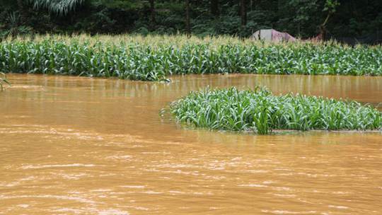
Yesterday, China had a wide range of precipitation. A new round of strong precipitation started in the south, and thunderstorms also occurred in parts of the north. Monitoring shows that, Heavy rain or rainstorm occurred in parts of southeast Sichuan, northern Chongqing, western Hubei, western Hunan, central and northern Guizhou, southern Guangxi, eastern Hainan Island, etc., and heavy rainstorm occurred in Qinzhou, Fangchenggang, Hainan Haikou, Wanning and other local areas in Guangxi; Moderate to heavy rain and local rainstorm occurred in parts of northeastern Inner Mongolia, central and western Heilongjiang, western Jilin and central and eastern Liaoning.
 Yesterday, heavy rainfall led to waterlogging in Qinzhou, Guangxi. (Fig/ Li Binxi )
Today, there is still a large area of precipitation in the south, and some areas in Jiangnan, South China and other places have rainstorm or Heavy rain , The rainwater in the north shrinks to the middle and north of the northeast; Tomorrow, the rainfall in South China will also be reduced and weakened, mainly affecting the coastal areas of South China.
Specifically, the Central Meteorological Observatory predicted that today, Some areas in northwest Heilongjiang, northeast Inner Mongolia, west of Sichuan Basin, southeast of southwest China, east of Jianghuai River, most of Jiangnan, north and west of South China have moderate to heavy rain, among which some areas in northeast Jiangxi, southwest Zhejiang, northwest Fujian, southeast Yunnan, and west Guangxi have heavy rain or heavy rain (100~110mm); There are light to moderate snow or sleet in eastern Tibet, central and southern Qinghai, western Sichuan Plateau, etc., and heavy to heavy snow in southeastern Qinghai, western Sichuan Plateau, etc.

tomorrow, Light to moderate rain occurs in parts of northwestern Heilongjiang, eastern Northeast China, southern Xinjiang Basin and northwest, central and southern Tibet, most of Qinghai, central and southern Jiangnan, most of southwest China, South China, Taiwan Island, etc., of which heavy rain (25-40mm) occurs in parts of eastern Fujian, southwestern Guangdong, southeastern Yunnan, etc ; There is light to moderate snow or sleet in eastern Tibet, central and southern Qinghai, western Sichuan Plateau, etc 。

the day after tomorrow, Some areas in Northeast Inner Mongolia, the north central part of Northeast China, the southern Xinjiang Basin and the north, northern and eastern Tibet, the central part of Northwest China, most of Southwest China, the south central part of South China, Taiwan Island and other places have light to moderate rain, of which some areas in coastal areas of southern Guangdong have heavy rain (25-30 mm).

The meteorological department reminds that after the end of this round of rainfall in the south, there will be two more rounds of rainfall from the 14th to the 15th and around the 18th. It is necessary to pay attention to the prevention of mountain torrents, geological disasters and other secondary disasters; The roads are slippery and the visibility is poor in rainy days. The public should pay attention to traffic safety when traveling to prevent the adverse effects of severe convection weather.
Strong wind and sand dust still exist in many places in the north. High temperature will appear in parts of North China and other places next week
Although the rainfall in the north is reduced today, due to the influence of cold vortex and cyclone, there will still be strong wind and sand dust in some areas. The Central Meteorological Observatory continued to issue a blue gale warning at 6:00 this morning. It is expected that, There are gales of 5~7 levels and gusts of 8~10 levels in central and western Inner Mongolia, central and western Heilongjiang, central and western Jilin, central and western Liaoning, northern Xinjiang and southern Xinjiang basin, northern Shanxi, northern Hebei, Tianjin, eastern Henan and other places 。 In addition, on the Southern Xinjiang, central and eastern Inner Mongolia, northern North China, etc Dust weather.
After the cold vortex, most parts of the north will be affected by the warm high ridge one after another, resulting in hot and dry weather. The temperature in some parts of Xinjiang to the west has taken the lead in climbing. For example, the highest temperature in Urumqi will reach 34 ℃ today. From 13th to 14th, the range of maximum temperature above 30 ℃ in the eastern part of northwest China, North China, Huang Huai River and other places expanded rapidly, and the temperature in many places will hit new highs this year.
As the temperature rises, the high temperature will also rise. Next week, there will be a hot weather of more than 40 ℃ near Turpan, Xinjiang. On the 14th, there will also be high temperature weather in northern Henan and southern Hebei. Zhengzhou may have the first high temperature of this year. Please pay attention to heatstroke prevention.