Xinzhi Satellite Map Mobile Edition It is a free mobile satellite map client. Rich high-definition map resources, whether you are indoors or outdoors, can intelligently plan the best route for you. The voice search function can easily query the route, so that you can travel without worry, and the kids in need can download and use it quickly!
Introduction to Xinzhi Satellite Map Free Edition
Professional explorer map, travel map, track map, map surveying map software, similar to Google Earth (google earth/google earth).

New satellite map latest version function
1. It integrates the navigation functions of Gaode Navigation and Baidu Navigation to provide 2265 users with path selection between two places;
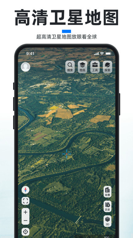
2. View the global world map anytime and anywhere, or call Google Satellite Map, Ovi Satellite Map, Google Street View and Google Maps in Chinese;
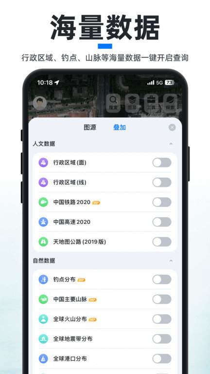
3. In the future, more cultural and natural data will be added: administrative regions, rivers and lakes, mountains and basins, surface coverage, meteorological data, marine data, etc., to serve geographic enthusiasts;
4. Powerful map annotation and point line plane calculation functions, including GPS track, altitude query, compass, azimuth map, offline map, compass, level, etc Utilities ;
How to use the Xinzhi satellite map app?
1. If you want to switch layers, click the layer button in the upper left corner

2. Then switch to Google Image Map

3. If you want to display roads and place names, click the button at the lower left corner

4. If you want to import kml, kmz, gpx and shp files, click the toolbox button in the upper left corner, and then click Data Import

How can I see people in the latest version of Xinzhi satellite map?
1. First, download the Xinzhi satellite map app, open it and select an address;

2. Click the portrait button when the map is known to be enlarged;

3. At this time, you can see the street view, and then click to download 3D;

4. Then you can see very high-definition people.

Software highlights
·You can share your location and track with your friends, or use satellite positioning based on the shared location to guide your friends out of the way! Track the location of friends and know their location in time;
·The software integrates Google Map Baidu Maps , Tencent Maps Gaud map 、 Ovi Interactive Map , Beidou satellite map Sogou Map View the real-time street view map, terrain map, image map, live map, 3d map, panoramic map of OSM, MapBox and other manufacturers together;
Update log
V4.1.0
1. Street view live broadcast function is newly launched, and the global street view camera can view it with one button
2. New home page shortcut button editing function, more convenient operation
3. The details of meteorological cloud map function are optimized, and the operation is more smooth
4. Fix known bugs
V3.6.3
New team collaboration function
Support 3D view of interest points, mapping and other data
Support sending interest points, mapping and other data within the application
V3.5.5 Version
1. The newly added guidebook function is convenient for you to make a better travel route
2. Fully optimize the track function to give you a better experience
3. Recommendation of new aerial photography materials
V3.4.9
1. Add mapping data export
2. Resolve the kml import offset
V3.1.6
1. Solve the problem of opening the application white screen
V3.0.7
repair Celestial map Superimposed BUG
V3.0.0
Optimization of hand drawing planning and track recording functions
New altitude query and map exploration functions
V2.0.0
1. Add offline map download;
2. Add Route planning Function;
3. Interface optimization and bug repair