At the ongoing 7th Digital China Construction Summit, China's Beidou satellite large-scale application achievements were unveiled. Relevant satellite applications are widely used in the fields of comprehensive traffic and transportation law enforcement, urban e-bike flow query, ship perception, and people flow perception in cultural and tourism attractions. Together, these applications have created the "Beidou Space Time Digital Intelligence Base", which has realized multi angle and all-round space-time data management.
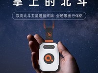
A marine economic space management panel made by Beidou terminal was displayed on site. This panel is based on the integrated communication facilities carried by offshore vessels, which can overcome the difficulties of traditional offshore communication such as short distance, high cost and low bandwidth, covering 80 km offshore, and meet the positioning requirements of most offshore fishing vessels, breeding fish rafts, offshore wind power, offshore engineering and other scenarios.
The staff also demonstrated using a Dajiang Matrix 3D UAV with built-in Beidou navigation function. Operators can take off UAV line patrol and return with one click only by importing routes on the platform, and solidify patrol flight paths and shooting positions through Beidou high-precision positioning technology, effectively improving patrol efficiency and operation standardization. The application of this UAV further demonstrates the potential and value of Beidou satellite in the aviation field.
This exhibition shows the remarkable achievements of the large-scale application of Beidou satellite in China, bringing more efficient and convenient data processing and positioning services to various industries. With the continuous development of Beidou system, it will be widely used in more fields in the future, bringing more convenience and possibility to people.
This article is an original article. If it is reproduced, please indicate the source: Intuitively display the trend of sea and land traffic flow, and Beidou large-scale application achievements show at the 2024 Digital China Construction Summit https://news.zol.com.cn/874/8742026.html
https://news.zol.com.cn/874/8742026.html
news.zol.com.cn
true
Zhongguancun Online
https://news.zol.com.cn/874/8742026.html
report
nine hundred and twenty-eight
At the ongoing 7th Digital China Construction Summit, China's Beidou satellite large-scale application achievements were unveiled. Relevant satellite applications are widely used in the fields of comprehensive traffic and transportation law enforcement, urban e-bike flow query, ship perception, and people flow perception in cultural and tourism attractions. Together, these applications have created the "Beidou Space Time Digital Intelligence Base", which has realized multi angle and all-round space-time data management. Now