Map navigation It can be said that the emergence of has saved many people's driving problems. Even if a person goes to an unfamiliar place, map navigation can help you easily reach the destination. However, there are still some kids who are difficult to see the map. It is difficult to connect 2D plane navigation with 3D reality. With navigation, they are still confused.
It can be said that map navigation can solve many problems, but the limitation of "not intuitive" also makes mobile phone Navigation has obvious limitations. Recently, Gaode Map App released a new version of v10.60 and launched the AR driving navigation function on the mobile phone, which can bring users a more intuitive route, direction and lane level live navigation experience. For those who "cannot understand" 2D electronic maps, The emergence of AR navigation may be a blessing.
Today, we also installed the latest Gaud map on our mobile phones. Let's go to see whether the Gaud map with AR navigation function can solve the problems mentioned above.
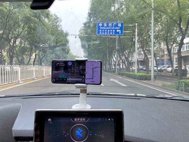
01 Opening preparation - mobile phone holder+ground calibration
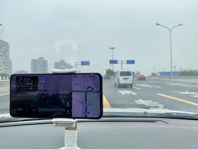
In order to drive safely, we fixed the mobile phone on the front window, opened the test at a position that is convenient for the driver to view but does not affect the vision, then adjusted the destination, and opened AR navigation for actual measurement.
After the AR navigation is turned on, Gaud Map will remind you to initialize the calibration. You need to aim the camera at the road and keep the phone horizontal. There will be a striking reference line on the phone screen to prompt you. As long as you fix the phone according to the operation, the whole calibration process is very simple and fast.
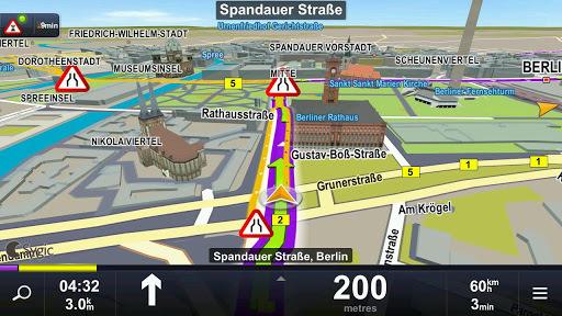
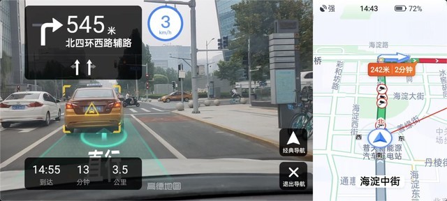
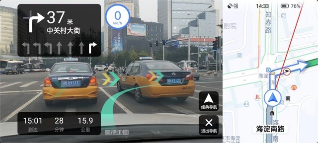
After opening, we can see that, with the help of intelligent image recognition technology, professional traffic big data and lane level navigation engine, Goddard AR Navigation can directly add "auxiliary lines" and "navigation guidance" in real time to the real road pictures taken, presenting navigation in 3D.
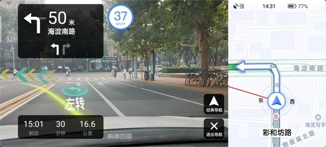
Moreover, after AR navigation is enabled, real-time AR scenes and traditional 2D map navigation will be presented on the left and right sides of the mobile phone screen at the same time to facilitate users to understand the navigation content. Of course, if you don't want to use AR navigation, you can also switch to classic navigation mode with one button.
Compared with traditional 2D electronic maps, Gaud's AR navigation can know the next operation only by looking at the screen, which eliminates the complex process of 2D maps being processed into 3D in the brain, and further reduces the time cost of map reading. Especially in a variety of key scenarios such as turning, crossing, lane changing, AR navigation can help users decide the next step more quickly and accurately.
02 Irregular driving, two lines of tears for relatives, safety first
After making sure that everything was well prepared, we started the navigation measurement, and looked at the processing method of Gaud's AR navigation according to various conditions on the road.
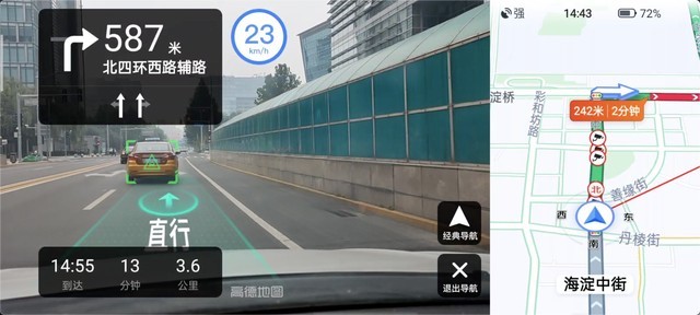
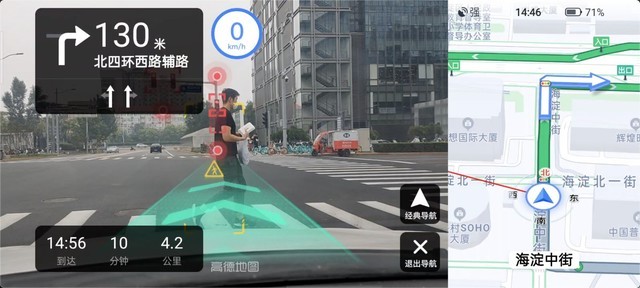
During normal driving, AR navigation will mark green on the driving road, so that drivers can intuitively understand the road they need to choose. If there are vehicles or pedestrians in front during driving, AR navigation will calculate the safe driving distance based on image recognition and distinguish it by color, so as to help drivers master the distance and drive more normatively and safely.
 Safe distance
 Distance adjustment required
In addition, Gaode AR Navigation can also carry out intelligent image recognition of lane lines, traffic signs, traffic lights and other surrounding environments, providing drivers with a series of driving safety aids such as lane departure reminders, ahead car start reminders, traffic light reminders, etc. Of course, in addition to the screen prompts added by AR navigation, the original navigation language prompts still exist, adding another layer of security for drivers.
 Traffic lights and pedestrian reminders
03 Can the measured Gaud map of multi scene AR navigation meet the challenge
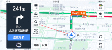
The map navigation usually prompts "turn left at 100m ahead", so where is the 100m ahead? There are also complex overpass intersections, an accidentally missed ramp on the expressway, and the forever confused merging problem... It is inevitable to encounter a variety of different road conditions during the driving process. Let's take a look at how the problems that are difficult to express clearly in traditional maps will be handled in the AR navigation in Gaode.
Taking the line merging problem that novice drivers often face as an example, according to the dynamic and static data such as navigation planning, current positioning, vehicle speed, road conditions and image recognition of the lane, Gaode AR Navigation will intelligently give lane change reminders at the appropriate time, and a yellow turning line and a striking "separation line" will be displayed in the mobile phone screen to distinguish the driving positions.
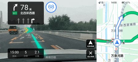
In addition, at the steering position, there will be a prominent "steering" icon on the mobile phone, and there will be an obvious steering line on the road to assist the driver in steering operations. It is also similar when encountering an interchange ramp. Gaud Map will voice a reminder when it is about to enter, add a striking operation prompt at the entry position, and use the 2D navigation on the side to clearly know the next operation mode.
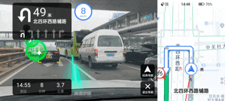
AR navigation is very useful, but "rollover" also exists. For example, the mobile phone in the following figure does not recognize that it is not on the right turn lane but on the straight lane, and it still reminds you to turn right according to the previous plan. At this time, it is illegal to choose to operate according to the prompts. Therefore, when using AR navigation, we should not be blind, and sometimes we need to plan the route according to the actual situation.
 Obviously, you can't turn right at this moment
04 One last word:
Through a series of tests, we can see that Gaud's AR map can really deliver the navigation content to the driver more intuitively, and can basically solve most of the problems encountered in the driving process in terms of driving planning. However, as this technology is still in its infancy, it is inevitable that "rollover" will occur. The intelligent algorithm is more of a reference. Drivers should make judgments based on the actual road conditions and use AR navigation as a driving aid.
However, with the maturity of technology, we can see that the application of AR technology can really bring convenience to life. The "navigation visualization" of AR driving also shows the concept of "technology changes life" vividly. I believe we can see more and more interesting AR scenarios in the future.
This article is an original article. If it is reproduced, please indicate the source: Mom, I finally "can find the north"! Gaode AR map experience //mobile.zol.com.cn/751/7512391.html
//mobile.zol.com.cn/751/7512391.html
mobile.zol.com.cn
true
Zhongguancun Online
//mobile.zol.com.cn/751/7512391.html
report
three thousand nine hundred and ninety-two
The emergence of map navigation can be said to have saved many people's driving problems. Even if a person goes to an unfamiliar place, map navigation can help you easily reach your destination. However, there are still some kids who are difficult to see the map. It is difficult to connect 2D plane navigation with 3D reality. With navigation, they are still confused. It can be said that map navigation can solve many problems, but "it is not straight enough..."


![[Slow hands] Glory 90 5G mobile phone, only 1737 yuan!](https://doc-fd.zol-img.com.cn/t_s240x160/g7/M00/05/07/ChMkLGZL6rGIFzKbAAF86n-wIsEAAeWwwMNZmgAAX0C720.jpg)
![[Slow hand without any] One Ace 3 gets 2586 yuan!](https://doc-fd.zol-img.com.cn/t_s240x160/g7/M00/05/07/ChMkK2ZL6hmIPj-EAAFYG-k2kC0AAeWwwIuhp0AAVgz616.jpg)
![[Slow hand] One plus 12 5G mobile phone, new design, easy to play](https://doc-fd.zol-img.com.cn/t_s240x160/g7/M00/05/07/ChMkLGZL6eSITlYFAAGhL0Y5jcEAAeWwwH9kZEAAaFH778.jpg)
![[Slow hands] Ten billion subsidies have come. One plus 12 flagship ships only sell for 3979 yuan](https://doc-fd.zol-img.com.cn/t_s240x160/g7/M00/05/07/ChMkK2ZL6UaIVYZhAAFiVFav4XAAAeWwgN89oEAAWJs281.jpg)
![[Slow hands] Meizu 21 Pro mobile phone price has fallen through! 4389 yuan can be taken home](https://doc-fd.zol-img.com.cn/t_s240x160/g7/M00/05/07/ChMkLGZL6SyIApfpAAFNgrw5ihcAAeWwgNI40kAAU2a670.jpg)
![[Slow hand] The original price is 2899, and the received price is 2499! Realme GT5 only sells for 2499 yuan](https://doc-fd.zol-img.com.cn/t_s240x160/g7/M00/05/07/ChMkK2ZL6ROILfySAAGXm_sRm6gAAeWwgMxhb8AAZez397.jpg)
![[Slow Handing] Glory 100 5G mobile phone is coming, the original price is 2999 yuan, and the price is 2489 yuan](https://doc-fd.zol-img.com.cn/t_s240x160/g7/M00/05/07/ChMkLGZL6NKIHTEeAAGKEJoj5GYAAeWwgI7t1cAAYoo796.jpg)
![[Slow hands] The Redmi Red Rice Turbo 3 5G mobile phone only costs 1594 yuan!](https://doc-fd.zol-img.com.cn/t_s240x160/g7/M00/05/07/ChMkLGZL6K2IE9zlAAJFCFeCaOAAAeWwgH3oRYAAkUg117.jpg)
![[Slow Handing] The price of vivo Y100 5G mobile phone is 1399 yuan!](https://doc-fd.zol-img.com.cn/t_s240x160/g7/M00/05/07/ChMkK2ZL6FKIc4xsAAEuaWEekj4AAeWwgGHSDcAAS6B836.jpg)
![[Slow in hand] Xiaomi 14 mobile phone JD limited time discount of 3699 yuan starts from 608 yuan](https://doc-fd.zol-img.com.cn/t_s240x160/g7/M00/05/07/ChMkK2ZL6CmIQPIzAAGoolA6HxQAAeWwgFahWEAAai6425.jpg)
![[Slow Handedness] OPPO A36 smartphone only sold for 599 yuan](https://doc-fd.zol-img.com.cn/t_s240x160/g7/M00/05/07/ChMkK2ZL59GIU0ktAAEttMt4IrsAAeWwgDu3GkAAS3M056.jpg)
![[Slow Handing] Limited time discount for iPhone 15 5G](https://doc-fd.zol-img.com.cn/t_s240x160/g7/M00/05/07/ChMkK2ZL56iIZx8yAACDxBDoUrQAAeWwQNP00kAAIPc806.jpg)
![[Slow Handing] The price of OPPO K12 mobile phone is only 1599 yuan!](https://doc-fd.zol-img.com.cn/t_s240x160/g7/M00/05/0C/ChMkK2YouSyIVC3IAACtWHJ9tfoAAdYGgMFMkAAAK1w639.jpg)
![[Manual slow without] The iQOO 12 Pro mobile phone has a direct drop of 520 yuan! Now start to exceed the value](https://doc-fd.zol-img.com.cn/t_s240x160/g7/M00/0D/06/ChMkK2YXkL-IJIUmAADEwfOpw90AAc2sgEGtbQAAMTZ994.jpg)
![[Slow hands] Ten billion subsidies are coming! OPPO Find X7 Ultra mobile phone price 4702 yuan](https://doc-fd.zol-img.com.cn/t_s240x160/g7/M00/05/06/ChMkK2ZL3AGIZXHTAAC-kz4HETQAAeWoQLpKuEAAL6r634.jpg)
![[Slow Hands] Meizu 21 Pro 5G mobile phone promotion price is 4389 yuan!](https://doc-fd.zol-img.com.cn/t_s240x160/g7/M00/03/08/ChMkK2XgeYqIbyqTAABXk4Mru6IAAbPEgO89vQAAFer811.jpg)
![[Slow hand] The iPhone 15 Pro has arrived, with powerful performance and excellent photography!](https://doc-fd.zol-img.com.cn/t_s240x160/g7/M00/05/06/ChMkLGZLzrOIFFW0AAD1xILqHtAAAeWnAPn8t8AAPXc791.jpg)
![[Slow hands] Xiaomi 13 Ultra mobile phone only costs 4307 yuan! High cost performance](https://doc-fd.zol-img.com.cn/t_s240x160/g7/M00/05/06/ChMkLGZLziiIRRg3AATESiZmJtkAAeWnAMeSFUABMRi825.png)
![[Slow Hands] Meizu 21 5G Mobile Phone Releases Snapdragon 8 Gen3 Flagship for Only 2775 yuan](https://doc-fd.zol-img.com.cn/t_s240x160/g7/M00/05/06/ChMkLGZLzhqIZrPkAAJraqKFXU8AAeWnAMTPNkAAmuC705.png)
![[Slow Handing] The price of iQOO Neo9 mobile phone is 1989 yuan!](https://doc-fd.zol-img.com.cn/t_s240x160/g7/M00/05/06/ChMkK2ZLzaeIBg4zAAE2lAsgLAQAAeWnAJfuf4AATas677.jpg)


![[Slow hands] Nubia Z60 Ultra 5G mobile phone 16GB+512GB Galaxy Snapdragon 8Gen3 3999](https://doc-fd.zol-img.com.cn/t_s240x160/g7/M00/07/09/ChMkK2YLrNqIIoPOAADnvIaut6wAAcfQwARYTEAAOfU072.jpg)

![[Slow Hands] Sony Xperia PRO-I 5G mobile phone 12GB+512GB black ushers in a promotional event](https://doc-fd.zol-img.com.cn/t_s240x160/g7/M00/0A/0D/ChMkLGYSIRKIQ6NqAADldOQ-_d4AAcsfgAOshEAAOWM227.jpg)