Eagle Eye is a set of track management services, providing SDKs and APIs at all ends for developers to access conveniently and track moving objects such as vehicles/people you manage.Based on the interface and cloud services provided by Eagle Eye, developers can quickly build a complete, accurate and high-performance track management system completely belonging to you, which can be applied to team management, personnel management and other fields.
Note: When you use this service, you promise and guarantee to disclose the use of relevant data to users using your products (web pages or applications), and ensure that you use the relevant services of Baidu Maps Open Platform to obtain user location data and other necessary data to provide relevant services when users are informed and authorized to do so.See details of specific privacy policyDeveloper Service Terms"7. Privacy Policy".
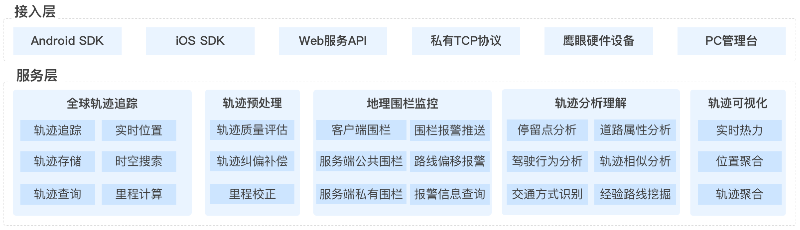
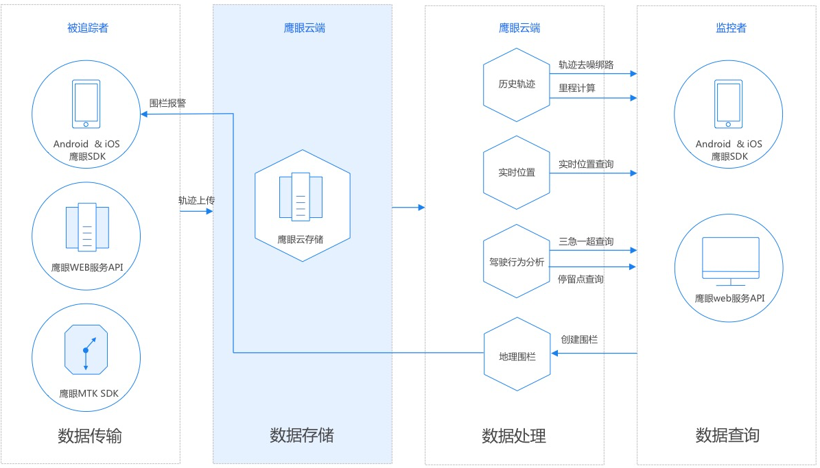
Hawkeye provides each application with more than 10 million terminal track management capabilities, and supports global track tracking.Eagle Eye provides a variety of APIs and SDKs for developers to track tracks from various terminals, such as mobile phones, satellite locators, smart rear-view mirrors and other hardware devices.In addition, Eagle Eye also supports developers to upload tracks from the server.
Track storage
Hawkeye stores track data of the last year for developers for free.Hawkeye adopts multi machine room and multi instance distributed storage, and automatically backs up regularly to ensure data storage security.
Track Query
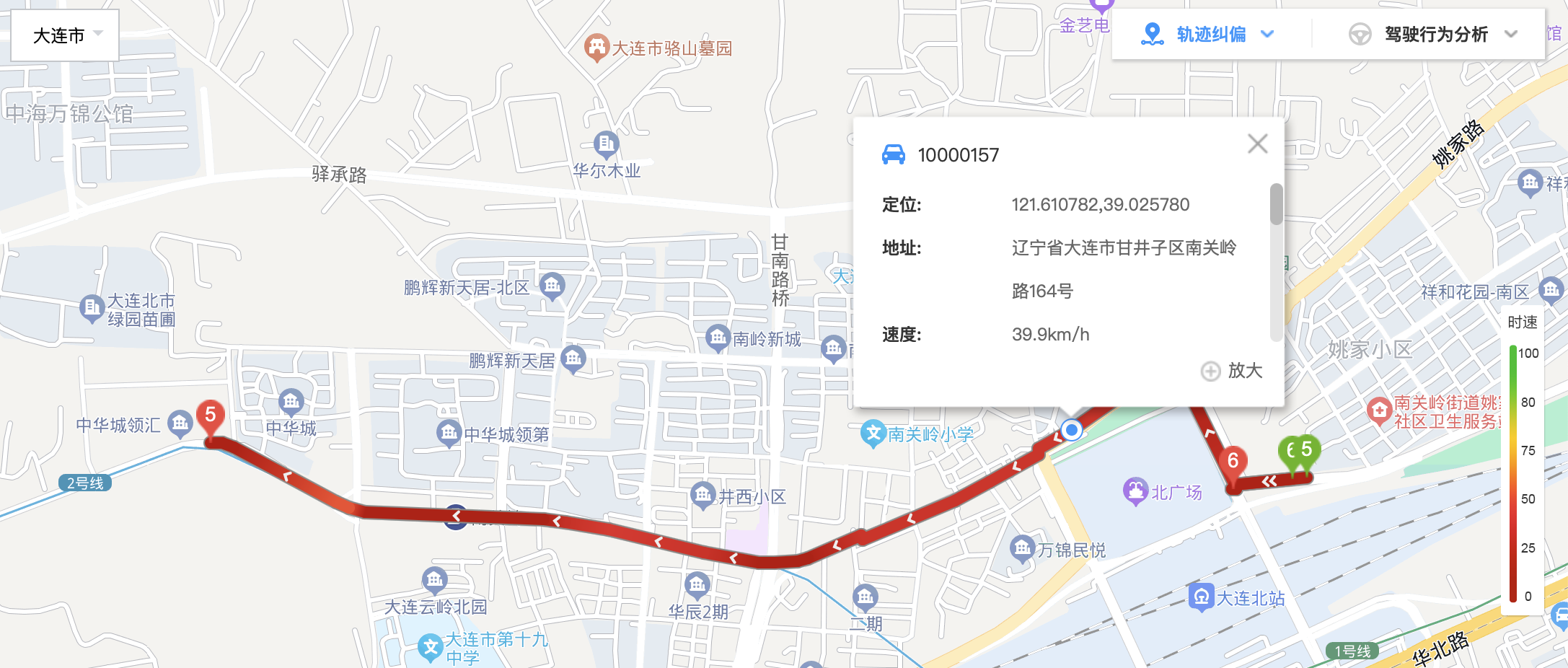
Using the Hawkeye high-performance track query service, developers can query the track at any time in real time.Real time query means that once a track point is successfully uploaded to the Eagle Eye Cloud, it can be queried through the interface in a timely manner, and the data delay is 100 milliseconds.Eagle Eye also provides track batch export function for developers to download historical track data.
Track correction and mileage calculation
In order to correct the track drift, Eagle Eye provides professional track correction, road binding and mileage calculation services.With this service, developers can correct track drift, display smooth and coherent tracks, and calculate accurate mileage.Eagle Eye provides different track correction and road binding algorithms for driving, cycling and walking, which are suitable for track correction of various vehicles.
Spatial retrieval
Eagle Eye provides rich spatial search capability, supports searching the real-time location of terminals within the circle, polygon and administrative region, and counts the number of terminals.With this service, developers can realize functions such as searching terminals in the current map view, terminals in Beijing, etc.
Geographic fence monitoring
Hawkeye provides geographic fence monitoring services. Developers can use Hawkeye to create polygon, route, administrative region and other types of geographic fences. Hawkeye automatically monitors the behavior of the terminal entering and exiting the fence, and pushes an alarm to the Hawkeye SDK or the developer server.With this service, developers can realize functions such as monitoring whether vehicles drive out of Haidian District by using the administrative fence, and monitoring whether logistics vehicles arrive at the station on time by using the polygon fence.
Trajectory analysis
Hawkeye provides developers with analysis of movement behaviors such as stopping points, overspeed (based on road speed limit), and rapid speed change.With this service, developers can analyze which stops are in a track and where dangerous driving behaviors such as speeding occur.
Experience route analysis
The Hawkeye experience route analysis service (beta version) can analyze the frequent routes of the terminal based on its historical track data for a period of time. The experience route information obtained from the analysis includes: 1Coordinates of starting and ending points of experience route 2Departure time interval and arrival time interval 3Route mileage, time consumption, average speed 4Alignment coordinate points
Image storage
In addition to tracks, Eagle Eye also supports the uploading of image data to help developers manage image data related to tracks (such as driving images, check-in photos, accident photos, etc.).
Eagle Eye Service Process
Hawkeye interface type
Based on the above functions, Eagle Eye provides various interfaces and products for developers to use Eagle Eye services:
1. Hawkeye web service API: a set of REST style APIs that provide all functions of Hawkeye in the form of HTTP/HTTPS for developers to call on the server and non Android/iOS platforms
2. Hawkeye Android SDK: for developers to use Hawkeye services on Android system devices (mobile phones, smart hardware, etc.)
3. Hawkeye iOS SDK: for developers to track tracks on iOS mobile phones and use all services of Hawkeye
4. Hawkeye hardware terminal: developers can directly purchase the satellite positioning equipment and rear-view mirror with integrated Hawkeye service, and track the track after installation.Developers can use eagle eye interface to query tracks
5. Web track management console: developers can view the real-time location and track of their own terminals after logging in